Dosiero:Antarctic Ocean location map.svg

Grando de tiu PNG antaŭprezento de tiu SVGa dosiero: 600 × 600 rastrumeroj. Aliaj distingivoj: 240 × 240 rastrumeroj | 480 × 480 rastrumeroj | 768 × 768 rastrumeroj | 1 024 × 1 024 rastrumeroj | 2 048 × 2 048 rastrumeroj | 709 × 709 rastrumeroj.
Bildo en pli alta difino (SVG-dosiero, 709 × 709 rastrumeroj, grandeco de dosiero: 243 KB)
| Jen dosiero de la Wikimedia-Komunejo. La priskribo en ties priskriba paĝo estas montrata suben.
|
Resumo
| Priskribo |
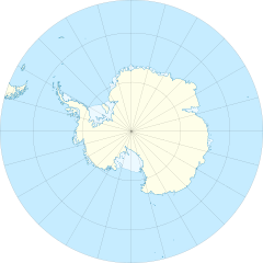
English: Location map of the Antarctic Ocean
|
| Dato | |
| Fonto | Propra verko |
| Aŭtoro | Tentotwo |
| Ceteraj versioj |
|

Permesiloj:
Mi, la posedanto de la aŭtorrajto por ĉi tiu verko, ĉi-maniere publikigas tiun laŭ la jena permesilo:
Ĉi tiu dosiero estas disponebla laŭ la permesilo Krea Komunaĵo Atribuite-Samkondiĉe 3.0 Neadaptita.
- Vi rajtas:
- kunhavigi – kopii, distribui kaj publikigi la verkon
- aliigi – modifi, adapti, kompletigi, transformi, uzi la tutan verkon aŭ ties partojn, memstare aŭ en aliaj verkoj
- La verko rajtas esti kunhavigata nur:
- atribuite – Vi devas atribui aŭtorecon, liveri ligilon al la permesilo kaj marki ĉu ŝanĝoj estis faritaj. Faru tion en aprobinda maniero, tamen ne sugestante, ke permesinto aprobas vin aŭ vian uzon.
- samkondiĉe – Se vi rekombinas la verkon, transformas ĝin aŭ kreas devenaĵon bazitan sur ĝi, vi rajtas distribui la rezultan verkon nur laŭ la sama aŭ kongrua permesilo kompare kun ĉi tiu.
Shell script for generating the map using GMT archive copy at the Wayback Machine
#!/bin/sh

# Set common options
PROJECTION=E0.0/-90.0/20.0c
REGION=-180/180/-90/-50
FILENAME=Antarctic_Ocean_location_map.ps

# Get Natural Earth datafiles
echo "Downloading datafiles from naturalearthdata.com"
wget -nv -nc \
 http://www.naturalearthdata.com/http//www.naturalearthdata.com/download/50m/physical/50m-coastline.zip\
 http://www.naturalearthdata.com/http//www.naturalearthdata.com/download/50m/physical/50m-land.zip\
 http://www.naturalearthdata.com/http//www.naturalearthdata.com/download/50m/cultural/50m-admin-0-boundary-lines.zip\
 http://www.naturalearthdata.com/http//www.naturalearthdata.com/download/50m/physical/50m-antarctic-ice-shelves-polys.zip\
 http://www.naturalearthdata.com/http//www.naturalearthdata.com/download/50m/physical/50m-antarctic-ice-shelves-lines.zip
echo "...done\n"

echo "Inflating archives"
unzip 50m\*.zip
echo "...done\n"

echo "Converting shapefiles to GMT"
ogr2ogr -F GMT 50m_land.gmt 50m_land.shp
ogr2ogr -F GMT 50m_coastline.gmt 50m_coastline.shp
ogr2ogr -F GMT 50m_borders.gmt ne_50m_admin_0_boundary_lines_land.shp
ogr2ogr -F GMT 50m_ice.gmt 50m_antarctic_ice_shelves_polys.shp
ogr2ogr -F GMT 50m_ice_borders.gmt 50m_antarctic_ice_shelves_lines.shp
echo "...done\n"

echo "Creating maps"
GMT psxy -m -J$PROJECTION -R$REGION -Bg15 --POLAR_CAP=none --BASEMAP_TYPE=plain --BASEMAP_AXES=N --FRAME_PEN=0.15p,black 50m_land.gmt -K -G254/254/233 > $FILENAME
GMT psxy -m -J$PROJECTION -R$REGION 50m_ice.gmt -O -K -G236/249/255 >> $FILENAME
GMT psxy -m -J$PROJECTION -R$REGION 50m_coastline.gmt -O -K -W0.535p,9/120/171  >> $FILENAME
GMT psxy -m -J$PROJECTION -R$REGION 50m_ice_borders.gmt -O -K -W0.27p,9/120/171  >> $FILENAME
GMT psxy -m -J$PROJECTION -R$REGION 50m_borders.gmt -O -W100/100/100  >> $FILENAME
echo "...done\n"

echo "You can now open $FILENAME in Inkscape to clean up the file and save it as SVG. You should add an ocean coloured background and simplify the graticules using CTRL+L."
Dosierhistorio
Alklaku iun daton kaj horon por vidi kiel la dosiero tiam aspektis.
| Dato/Horo | Bildeto | Grandecoj | Uzanto | Komento | |
|---|---|---|---|---|---|
| nun | 13:46, 27 jan. 2012 | | 709 × 709 (243 KB) | Tentotwo |
Dosiera uzado
La jena paĝo ligas al ĉi tiu dosiero:
Suma uzado de la dosiero
La jenaj aliaj vikioj utiligas ĉi tiun dosieron:
- Uzado en az.wikipedia.org
- Uzado en bg.wikipedia.org
- Uzado en ce.wikipedia.org
- Uzado en de.wikipedia.org
- Uzado en en.wikisource.org
- User:EncycloPetey
- User talk:Zyephyrus
- User:Kathleen.wright5
- User:George Orwell III
- User:Magnus Manske
- User:William Maury Morris II
- User:Tannertsf
- User:Mpaa
- User:Beeswaxcandle/Works
- User:WeeJeeVee
- User:Slowking4
- User:Legofan94
- User:GreyHead
- User:Keith Edkins/Participation archive
- User:HueSatLum
- User:Pixelwarrior
- User:Denis Barthel
- User:WhatamIdoing
- User:Sushant savla
- User:EncycloPetey/Userboxes
- Uzado en es.wikipedia.org
- Uzado en fr.wikipedia.org
- Uzado en gl.wikipedia.org
- Uzado en hu.wikipedia.org
- Uzado en hy.wikipedia.org
- Uzado en ka.wikipedia.org
- Uzado en kk.wikipedia.org
- Uzado en lv.wikipedia.org
- Uzado en pl.wikipedia.org
- Uzado en pl.wikibooks.org
- Uzado en pl.wiktionary.org
Vidi plian ĝeneralan uzadon de ĉi tiu dosiero.