Dosiero:Eifel - Deutsche Mittelgebirge, Serie A-de.png
Bildo en pli alta difino ((2 500 × 2 600 rastrumeroj, grandeco de dosiero: 9,83 MB, MIME-tipo: image/png))
| Jen dosiero de la Wikimedia-Komunejo. La priskribo en ties priskriba paĝo estas montrata suben.
|
Resumo
| Priskribo |
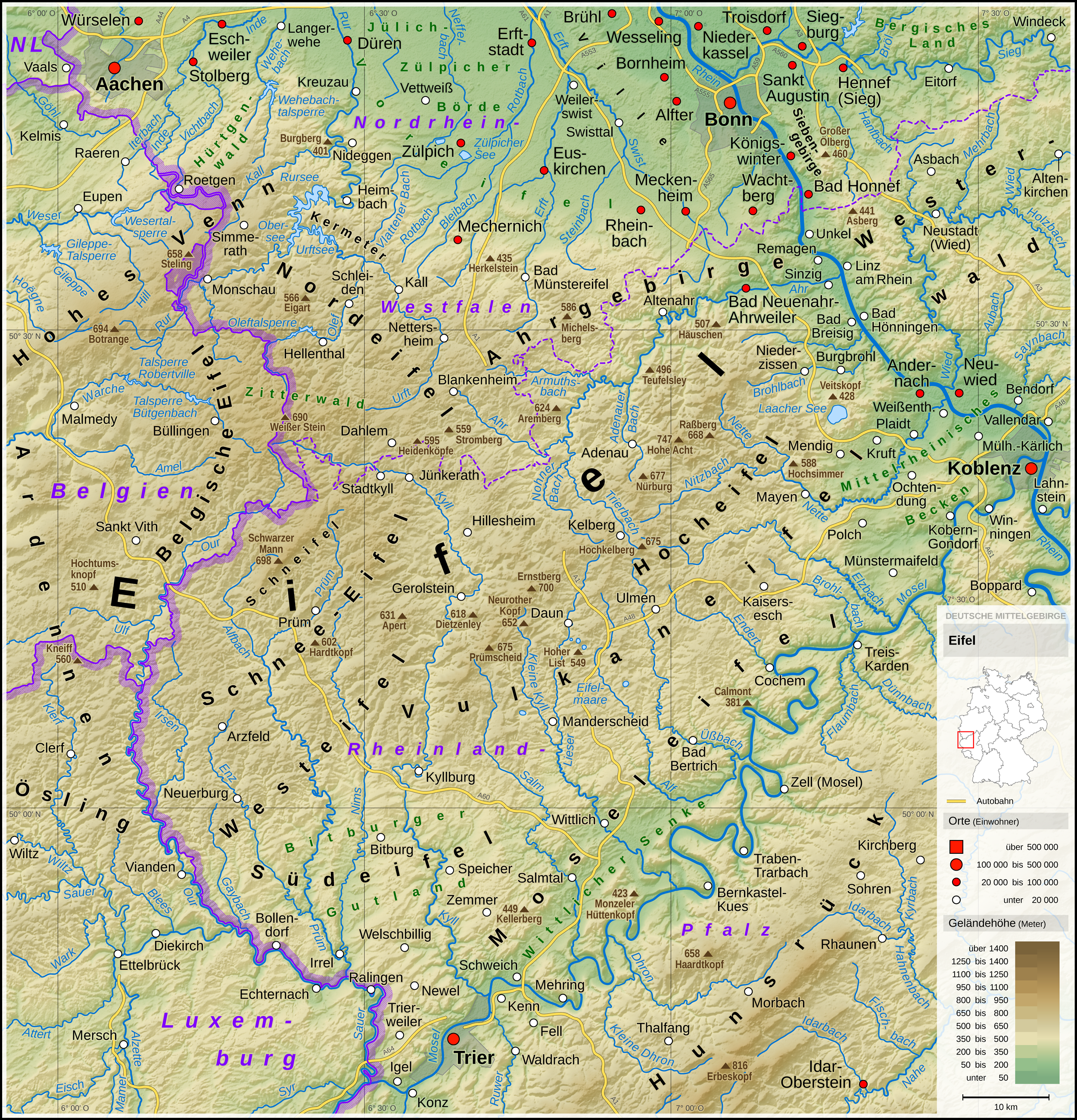
English: Topographic map of the Eifel
Deutsch: Topografische Karte der Eifel |
||||||||||||||||||
| Dato | |||||||||||||||||||
| Fonto |
Own work using: |
||||||||||||||||||
| Aŭtoro | Thoroe | ||||||||||||||||||
| Ceteraj versioj |
 Topographic maps of German low mountain ranges (A series)
This map series aims to show the major low mountain ranges of Germany in a uniform design. All maps are created on the same scale, and the background reliefs base upon the same color scheme. The reliefs are also available as separate files. You can find the making-of one of the maps in the German language Wikipedia (German only).
|
||||||||||||||||||


_-_Deutsche_Mittelgebirge,_Serie_A-de.png)
_-_Deutsche_Mittelgebirge,_Serie_A-de.png)
_-_Deutsche_Mittelgebirge,_Serie_A-de.png)
_-_Deutsche_Mittelgebirge,_Serie_A-de.png)
_-_Deutsche_Mittelgebirge,_Serie_A-de.png)
_-_Deutsche_Mittelgebirge,_Serie_A-de.png)
_-_Deutsche_Mittelgebirge,_Serie_A-de.png)
_-_Deutsche_Mittelgebirge,_Serie_A-de.png)
_-_Deutsche_Mittelgebirge,_Serie_A-de.png)
_-_Deutsche_Mittelgebirge,_Serie_A-de.png)
_-_Deutsche_Mittelgebirge,_Serie_A-de.png)
_-_Deutsche_Mittelgebirge,_Serie_A-de.png)
_-_Deutsche_Mittelgebirge,_Serie_A-de.png)
_-_Deutsche_Mittelgebirge,_Serie_A-de.png)
_-_Deutsche_Mittelgebirge,_Serie_A-de.png)
_-_Deutsche_Mittelgebirge,_Serie_A-de.png)
_-_Deutsche_Mittelgebirge,_Serie_A-de.png)
_-_Deutsche_Mittelgebirge,_Serie_A-de.png)
_-_Deutsche_Mittelgebirge,_Serie_A-de.png)
_-_Deutsche_Mittelgebirge,_Serie_A-de.png)
_-_Deutsche_Mittelgebirge,_Serie_A-de.png)
_-_Deutsche_Mittelgebirge,_Serie_A-de.png)
_-_Deutsche_Mittelgebirge,_Serie_A-de.png)
_-_Deutsche_Mittelgebirge,_Serie_A-de.png)
_-_Deutsche_Mittelgebirge,_Serie_A-de.png)
_-_Deutsche_Mittelgebirge,_Serie_A-de.png)
_-_Deutsche_Mittelgebirge,_Serie_A-de.png)
_-_Deutsche_Mittelgebirge,_Serie_A-de.png)
_-_Deutsche_Mittelgebirge,_Serie_A-de.png)
_-_Deutsche_Mittelgebirge,_Serie_A-de.png)
_-_Deutsche_Mittelgebirge,_Serie_A-de.png)
_-_Deutsche_Mittelgebirge,_Serie_A-de.png)
| This work contains information from OpenStreetMap, which is made available under the Open Database License (ODbL).
The ODbL does not require any particular license for maps produced from ODbL data. Prior to 1 August 2020, map tiles produced by the OpenStreetMap Foundation were licensed under the CC-BY-SA-2.0 license. Maps produced by other people may be subject to other licences. |

|
This map has been made or improved in the German Kartenwerkstatt (Map Lab). You can propose maps to improve as well.
|
Permesiloj:
- Vi rajtas:
- kunhavigi – kopii, distribui kaj publikigi la verkon
- aliigi – modifi, adapti, kompletigi, transformi, uzi la tutan verkon aŭ ties partojn, memstare aŭ en aliaj verkoj
- La verko rajtas esti kunhavigata nur:
- atribuite – Vi devas atribui aŭtorecon, liveri ligilon al la permesilo kaj marki ĉu ŝanĝoj estis faritaj. Faru tion en aprobinda maniero, tamen ne sugestante, ke permesinto aprobas vin aŭ vian uzon.
- samkondiĉe – Se vi rekombinas la verkon, transformas ĝin aŭ kreas devenaĵon bazitan sur ĝi, vi rajtas distribui la rezultan verkon nur laŭ la sama aŭ kongrua permesilo kompare kun ĉi tiu.
| Annotations | This image is annotated: View the annotations at Commons |
Dosierhistorio
Alklaku iun daton kaj horon por vidi kiel la dosiero tiam aspektis.
| Dato/Horo | Bildeto | Grandecoj | Uzanto | Komento | |
|---|---|---|---|---|---|
| nun | 10:53, 13 maj. 2017 | | 2 500 × 2 600 (9,83 MB) | Thoroe | Brohlbach (Mosel) korr. |
| 23:05, 10 maj. 2017 |  | 2 500 × 2 600 (9,82 MB) | Thoroe | + Stadtkyll | |
| 13:56, 7 maj. 2017 |  | 2 500 × 2 600 (9,82 MB) | Thoroe | 1st revision | |
| 20:37, 4 maj. 2017 |  | 2 500 × 2 600 (9,82 MB) | Thoroe | {{Information |Description ={{en|1=Topographic map of the Eifel}} {{de|1=Topografische Karte der Eifel}} |Source ={{Own using}} *[http://gmt.soest.hawaii.edu Generic Mapping Tools (GMT)] with [http://dds.cr.usgs.g... |
Dosiera uzado
La jenaj paĝoj ligas al ĉi tiu dosiero:
Suma uzado de la dosiero
La jenaj aliaj vikioj utiligas ĉi tiun dosieron:
- Uzado en arz.wikipedia.org
- Uzado en bn.wikipedia.org
- Uzado en ca.wikipedia.org
- Uzado en da.wikipedia.org
- Uzado en de.wikipedia.org
- Eifel
- Vulkaneifel
- Wittlicher Senke
- Winterspelt (Andersch)
- Schneifel
- Östliche Hocheifel
- Ahrgebirge
- Rureifel
- Nordeifel
- Südeifel
- Zitterwald
- Portal:Eifel
- Kermeter
- Hürtgenwald (Forst)
- Wikipedia:Kartenwerkstatt/Kartenwünsche
- Moseleifel
- Liste von Bergen und Erhebungen der Eifel
- Voreifel
- Liste der naturräumlichen Einheiten in Rheinland-Pfalz
- Benutzer:Thoroe
- Bitburger Gutland
- Wikipedia:Kartenwerkstatt/Archiv/2017-05
- Prümscheid (Naturraum)
- Benutzer:Thoroe/Making of Thüringer Wald
- Uzado en de.wiktionary.org
- Uzado en el.wikipedia.org
- Uzado en en.wikipedia.org
- Uzado en en.wikivoyage.org
- Uzado en es.wikipedia.org
- Uzado en et.wikipedia.org
- Uzado en fa.wikipedia.org
- Uzado en fi.wikipedia.org
- Uzado en frr.wikipedia.org
- Uzado en fr.wikipedia.org
- Uzado en fr.wiktionary.org
- Uzado en gl.wikipedia.org
- Uzado en hu.wikipedia.org
Vidi plian ĝeneralan uzadon de ĉi tiu dosiero.