Dosiero:St. John, U.S. Virgin Islands.jpg

Grandeco de ĉi antaŭvido: 600 × 600 rastrumeroj. Aliaj distingivoj: 240 × 240 rastrumeroj | 480 × 480 rastrumeroj | 768 × 768 rastrumeroj | 1 024 × 1 024 rastrumeroj | 2 400 × 2 400 rastrumeroj.
Bildo en pli alta difino ((2 400 × 2 400 rastrumeroj, grandeco de dosiero: 2,74 MB, MIME-tipo: image/jpeg))
| Jen dosiero de la Wikimedia-Komunejo. La priskribo en ties priskriba paĝo estas montrata suben.
|
Resumo
| Priskribo |
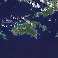
English: Natural-colour image of the Island of St. John island in the United States Virgin Islands.
|
| Dato | |
| Fonto | NASA Earth Observatory |
| Aŭtoro | Jesse Allen and Robert Simmon |
| Ceteraj versioj |


.jpg)

Image captured by the Advanced Land Imager (ALI) on NASA’s Earth Observing-1 (EO-1) satellite. EO-1 ALI data provided courtesy of the NASA EO-1 team.
Permesiloj:
| La ĉi-supra dosiero estas publika havaĵo, ĉar ĝi apartenas al NASA. La kopirajta regularo de NASA asertas, ke "ĉiuj dokumentoj de NASA estas publika havaĵo, se ne estas donata kontraŭa deklaro". | ||
 |
Atentu:
|
| Annotations | This image is annotated: View the annotations at Commons |
Dosierhistorio
Alklaku iun daton kaj horon por vidi kiel la dosiero tiam aspektis.
| Dato/Horo | Bildeto | Grandecoj | Uzanto | Komento | |
|---|---|---|---|---|---|
| nun | 10:13, 20 jan. 2011 | | 2 400 × 2 400 (2,74 MB) | Originalwana | {{Information |Description={{en|1=Natural-colour image of the eastern half of St. John. Settlements—marked by curving roads and light roofs—line the irregular coastline. The pinpoints of white in Coral Bay are probably boats. The island’s interior |
Dosiera uzado
La jena paĝo ligas al ĉi tiu dosiero:
Suma uzado de la dosiero
La jenaj aliaj vikioj utiligas ĉi tiun dosieron:
- Uzado en arz.wikipedia.org
- Uzado en ast.wikipedia.org
- Uzado en ca.wikipedia.org
- Uzado en ceb.wikipedia.org
- Uzado en cy.wikipedia.org
- Uzado en en.wikipedia.org
- Uzado en en.wikisource.org
- Uzado en es.wikipedia.org
- Uzado en eu.wikipedia.org
- Uzado en fi.wikipedia.org
- Uzado en frr.wikipedia.org
- Uzado en fr.wikivoyage.org
- Uzado en gl.wikipedia.org
- Uzado en id.wikipedia.org
- Uzado en lb.wikipedia.org
- Uzado en pl.wikipedia.org
- Uzado en tg.wikipedia.org
- Uzado en tl.wikipedia.org
- Uzado en uk.wikipedia.org
- Uzado en vec.wikipedia.org
- Uzado en www.wikidata.org