Dosiero:1806 Cary Map of Tartary or Central Asia - Geographicus - Tartary-cary-1806.jpg

Bildo en pli alta difino((5 000 × 4 569 rastrumeroj, grandeco de dosiero: 8,57 MB, MIME-tipo: image/jpeg))

Jen dosiero de la Wikimedia-Komunejo. La priskribo en ties priskriba paĝo estas montrata suben.
La Komunejo estas dosieruja retejo de libere licencitaj dosieroj.
John Cary: A New Map of Mongolian & Independent Tartary , From the Latest Authorities.   (Wikidata search (Cirrus search) Wikidata query (SPARQL)  Create new Wikidata item based on this file)
Artisto/Kreinto
John Cary  (–1835)  wikidata:Q3446124 s:en:Author:John Cary
 
Alternativaj nomoj
J. Cary
Priskribo kartografo, gravuristo, mapseller, printseller kaj grafikartisto
Dato de naskiĝo/morto la 23-a de februaro 1755 / 1754 Edit this at Wikidata la 16-a de aŭgusto 1835 Edit this at Wikidata
Loko de naskiĝo/morto Corsley Mortlake
Laborperiodo 1788 / 1793 / 1797 Edit this at Wikidata
Loko de laboro
Norma datumaro
artist QS:P170,Q3446124
Titolo
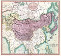
A New Map of Mongolian & Independent Tartary , From the Latest Authorities.
Priskribo
English: An exceptionally beautiful example of John Cary’s important 1806 map of Mongolian and Independent Tartary. Covers Central Asia from the Caspian Sea to Japan, extends as far north as the Obskaia Sea and as far south as India, Burma and the Philippines. Includes the modern day nations of Uzbekistan, Kazakhstan, Turkmenistan, Kirgizstan, Tajikistan and Mongolia. One of Cary’s most interesting maps. Central Asia, despite hundreds of years of passing trade on the Silk Routes, was still, at the turn of the century a largely unknown land. Cary attempts to show some of the Silk Route passages, especially to the north of the Gobi, but ultimately admits, “The Geography of these parts is extremely obscure.” All in all, one of the most interesting and few maps of Central Asia to appear in first years of the 19th century. Prepared in 1806 by John Cary for issue in his magnificent 1808 New Universal Atlas. (NOTE: The reproduction of the colors in this map appear to be incorrect, as Japan and Tibet were never part of Chinese Tartary yet appear to be the same color as it.)
Dato 1806 (dated)
Dimensioj alto: 18,5 coloj (46,9 cm); larĝo: 20 coloj (50,8 cm)
dimensions QS:P2048,18.5U218593
dimensions QS:P2049,20U218593
Akirnumero
Geographicus link: Tartary-cary-1806
Fonto/Fotisto

Cary, John, Cary's New Universal Atlas, containing distinct maps of all the principal states and kingdoms throughout the World. From the latest and best authorities extant. London: Printed for J. Cary, Engraver and Map-seller, No. 181, near Norfolk Street, Strand, 1808.

Permeso
(Reuzo de la dosiero)
Ĉi tio estas fidela fotografia reproduktaĵo de originala dudimensia artverko. La artverko mem estas publika havaĵo pro jena kialo:
Public domain

Tiu ĉi verko estas publika havaĵo en tiuj landoj, kies kopirajtado validas por longo de vivo plus 100 jaroj aŭ malpli.


You must also include a United States public domain tag to indicate why this work is in the public domain in the United States.
La oficiala sinteno de la Vikimedia Fondaĵo estas ke "fidelaj reproduktaĵoj de dudimensiaj publikhavaĵaj artverkoj estas publika havaĵo, kaj malaj asertoj prezentas atakon al la esenco de la publikhavaĵa koncepto". Vidu detalojn ĉe Commons:When to use the PD-Art tag.
Tiu ĉi fotografia reproduktaĵo estas sekve ankaŭ konsiderata publika havaĵo. Bonvolu atenti ke, depende de lokaj leĝoj, reuzo de tiu ĉi enhavo povas esti malpermesita aŭ limigita en via jurisdikcio. Vidu Commons:Reuse of PD-Art photographs.
Ceteraj versioj
Annotations
InfoField
This image is annotated: View the annotations at Commons

Titoloj

Donu unulinian priskribon de la enhavo de ĉi tiu dosiero

Eroj prezentitaj en ĉi tiu dosiero

montras

image/jpeg

3d7f1be3ae7a9539d26d91394bee37e7dc951779

8 990 511 bajto

4 569 rastrumero

5 000 rastrumero

Dosierhistorio

Alklaku iun daton kaj horon por vidi kiel la dosiero tiam aspektis.

Dato/HoroBildetoGrandecojUzantoKomento
nun08:56, 19 aŭg. 2019Bildeto por versio ekde 08:56, 19 aŭg. 20195 000 × 4 569 (8,57 MB)SoerfmBrightness, color
10:56, 22 mar. 2011Bildeto por versio ekde 10:56, 22 mar. 20115 000 × 4 569 (7,81 MB)BotMultichillT{{subst:User:Multichill/Geographicus |link=http://www.geographicus.com/P/AntiqueMap/Tartary-cary-1806 |product_name=1806 Cary Map of Tartary or Central Asia |map_title=A New Map of Chinese & Independent Tartary , From the Latest Authorities. |description=

La jena paĝo ligas al ĉi tiu dosiero:

Suma uzado de la dosiero

La jenaj aliaj vikioj utiligas ĉi tiun dosieron:

Metadatumoj