Dosiero:Azores old map.jpg

Bildo en pli alta difino ((2 104 × 1 480 rastrumeroj, grandeco de dosiero: 678 KB, MIME-tipo: image/jpeg))
| Jen dosiero de la Wikimedia-Komunejo. La priskribo en ties priskriba paĝo estas montrata suben.
|
Resumo

|
Tiu ĉi bildo old map respektive ĉiuj bildoj en tiu ĉi artikolo aŭ kategorio prefere estu rekreata(j) kiel vektora grafikaĵo en la formato SVG. Vektoraj formatoj por grafikaĵoj havas multajn avantaĝojn, detaloj troveblas anglalingve en la komuneja artikolo Commons:Media for cleanup. Se vi havas aŭ kreas SVG-version de tiu ĉi bildo, bonvolu alŝuti ĝin al la vikipedia komunejo. Post tiu ago, ĉi tiu ŝablono en la bildpaĝo estas anstataŭigenda per la ŝablono {{vector version available|nova dosiera nomo.svg}}.
|


| Priskribo |
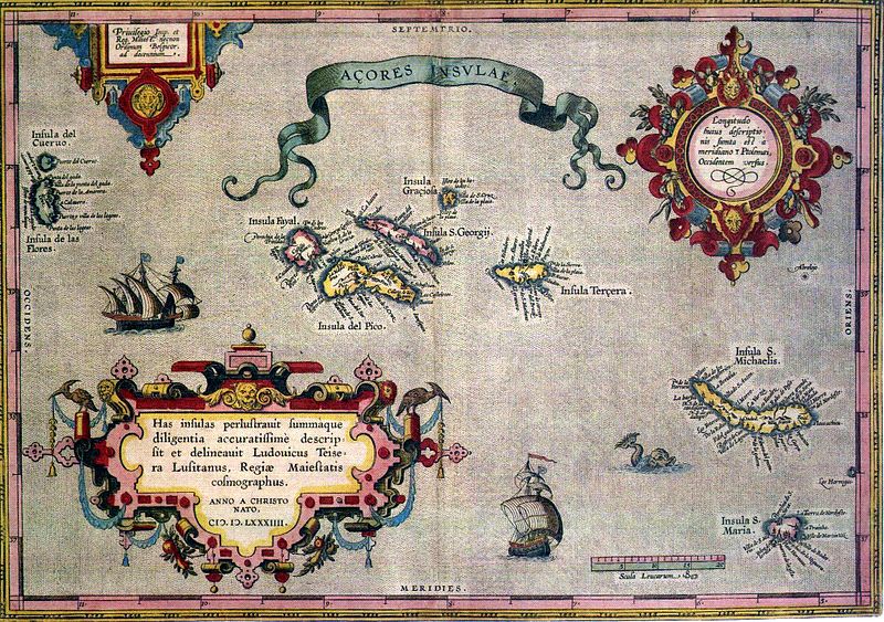
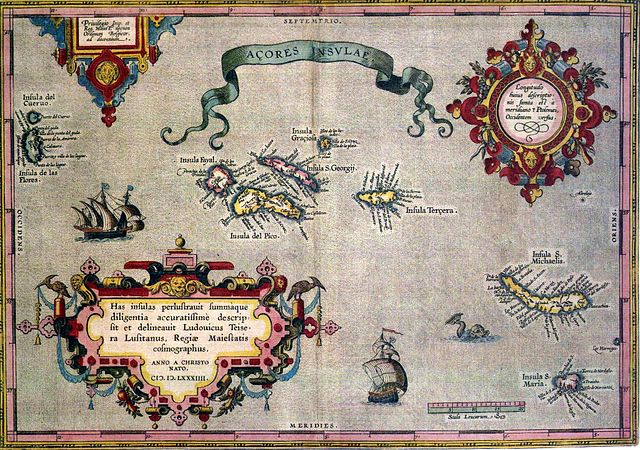
English: Sixteenth-century map of Azores. Legend, in Latin: "Has insulas perlustrauit summàque diligentia accuratissimè descripsit et delineauit Ludovicus Teisera Lusitanus, Regiæ Maiestatis cosmographus. ANNO A CHRISTO NATO, M.D.LXXXIIII" ("These islands were illustrated and described with great diligence and drawn by the Portuguese Luís Teixeira, his royal majesty's cartographer, AD 1584.") Deutsch: alte Karte der Azoren Português: "Açores Insulae" ("Ilhas dos Açores"), Luís Teixeira, c. 1584. A legenda, em latim - "Has insulas perlustrauit summàque diligentia accuratissimè descripsit et delineauit Ludovicus Teisera Lusitanus, Regiæ Maiestatis cosmographus. ANNO A CHRISTO NATO, M.D.LXXXIIII" -, pode ser traduzida livremente como: "Estas ilhas foram percorridas com a maior diligência, e com todo o cuidado as descreveu o português Luís Teixeira, cosmógrafo da Majestade Real. Ano do nascimento de Cristo de 1584." |
| Dato | |
| Fonto | see above |
| Aŭtoro | Abraham Ortelius |
Permesiloj:
|
Ĉi tio estas fidela fotografia reproduktaĵo de originala dudimensia artverko. La artverko mem estas publika havaĵo pro jena kialo:
La oficiala sinteno de la Vikimedia Fondaĵo estas ke "fidelaj reproduktaĵoj de dudimensiaj publikhavaĵaj artverkoj estas publika havaĵo, kaj malaj asertoj prezentas atakon al la esenco de la publikhavaĵa koncepto". Vidu detalojn ĉe Commons:When to use the PD-Art tag. Tiu ĉi fotografia reproduktaĵo estas sekve ankaŭ konsiderata publika havaĵo. Bonvolu atenti ke, depende de lokaj leĝoj, reuzo de tiu ĉi enhavo povas esti malpermesita aŭ limigita en via jurisdikcio. Vidu Commons:Reuse of PD-Art photographs. {{PD-Art}} template without license parameter: please specify why the underlying work is public domain in both the source country and the United States
(Usage: {{PD-Art|1=|deathyear=''year of author's death''|country=''source country''}}, where parameter #1 can be PD-old-auto, PD-old-auto-expired, PD-old-auto-1996, PD-old-100 or similar. See Commons:Multi-license copyright tags for more information.) | ||||
Dosierhistorio
Alklaku iun daton kaj horon por vidi kiel la dosiero tiam aspektis.
| Dato/Horo | Bildeto | Grandecoj | Uzanto | Komento | |
|---|---|---|---|---|---|
| nun | 06:59, 17 jul. 2005 | | 2 104 × 1 480 (678 KB) | Nataraja~commonswiki | |
| 02:16, 17 jul. 2005 |  | 2 104 × 1 480 (635 KB) | Angrense | Abraham Ortelius map of the Azores (c. 1585). {{PD}} Category:Azores |
Dosiera uzado
La jena paĝo ligas al ĉi tiu dosiero:
Suma uzado de la dosiero
La jenaj aliaj vikioj utiligas ĉi tiun dosieron:
- Uzado en als.wikipedia.org
- Uzado en an.wikipedia.org
- Uzado en ca.wikipedia.org
- Uzado en da.wikipedia.org
- Uzado en de.wikipedia.org
- Uzado en el.wikipedia.org
- Uzado en en.wikipedia.org
- Uzado en es.wikipedia.org
- Uzado en fa.wikipedia.org
- Uzado en fi.wikipedia.org
- Uzado en fr.wikipedia.org
- Uzado en gl.wikipedia.org
- Uzado en id.wikipedia.org
- Uzado en is.wikipedia.org
- Uzado en it.wikipedia.org
- Uzado en la.wikipedia.org
- Uzado en mk.wikipedia.org
- Uzado en nds-nl.wikipedia.org
- Uzado en nn.wikipedia.org
- Uzado en no.wikipedia.org
- Uzado en pt.wikipedia.org
- Uzado en ru.wikipedia.org
- Uzado en sh.wikipedia.org
- Uzado en sk.wikipedia.org
Vidi plian ĝeneralan uzadon de ĉi tiu dosiero.