Dosiero:British bechuanaland 1887.jpg

Bildo en pli alta difino ((1 644 × 1 627 rastrumeroj, grandeco de dosiero: 181 KB, MIME-tipo: image/jpeg))
| Jen dosiero de la Wikimedia-Komunejo. La priskribo en ties priskriba paĝo estas montrata suben.
|
Resumo
| Priskribo |
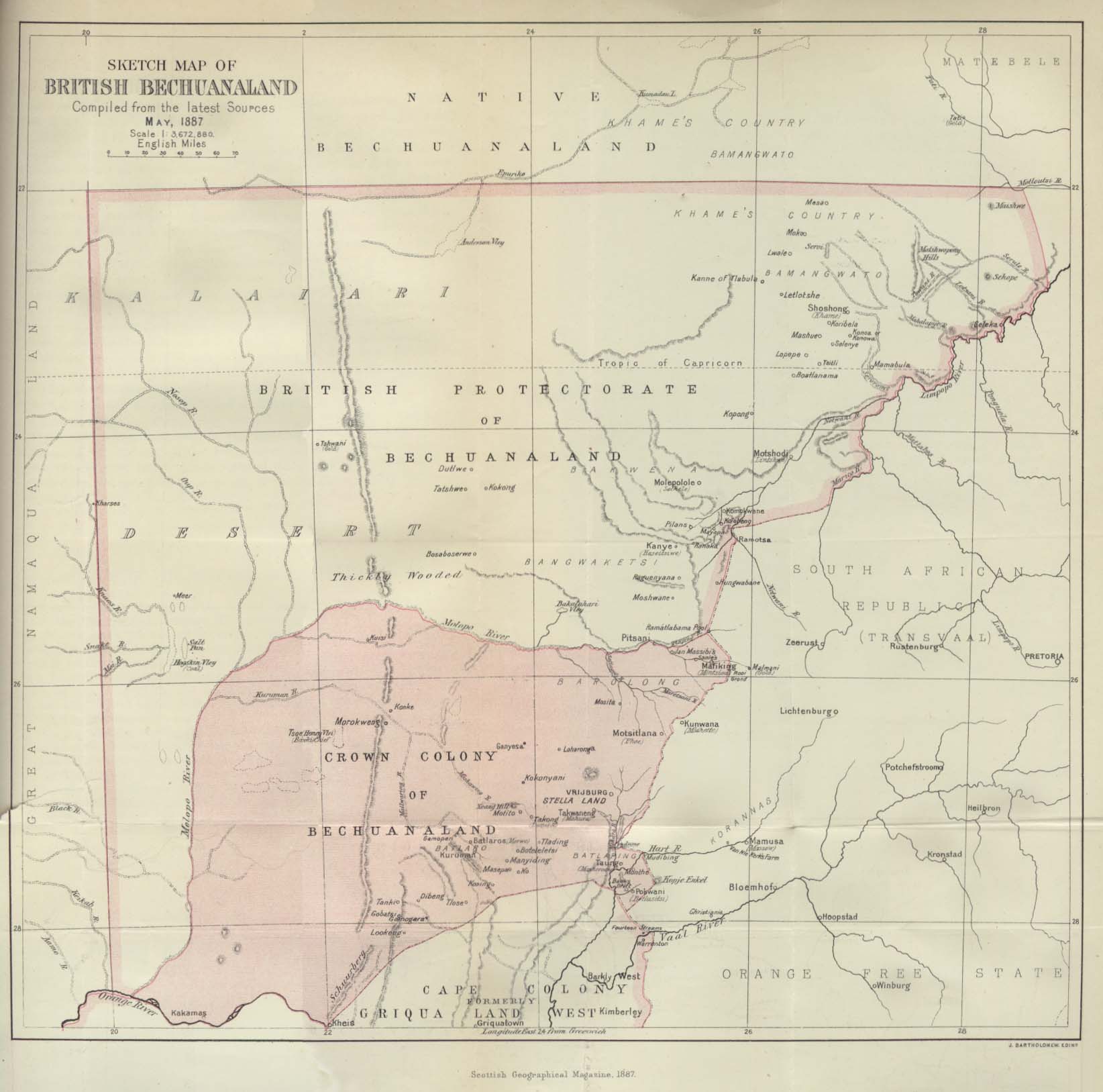
Deutsch: Karte von Betschuanaland, Mai 1887.
English: Sketch Map of British Bechuanaland, May 1887. |
| Dato | |
| Fonto |
The Scottish Geographical Magazine. Published by the Scottish Geographical Society and edited by Arthur Silva White. Volume III, 1887. |
| Aŭtoro | John George Bartholomew |
Permesiloj:
|
Tiu ĉi verko estas publika havaĵo en tiuj landoj, kies kopirajtado validas por longo de vivo plus 70 jaroj aŭ malpli.
| |
| Estis konkludite ke uzon de ĉi tiu dosiero limigas neniu konata aŭtorrajta leĝo, kio inkluzivas ĉiujn rilatajn kaj apudajn rajtojn. | |
Dosierhistorio
Alklaku iun daton kaj horon por vidi kiel la dosiero tiam aspektis.
| Dato/Horo | Bildeto | Grandecoj | Uzanto | Komento | |
|---|---|---|---|---|---|
| nun | 21:09, 24 aŭg. 2005 | | 1 644 × 1 627 (181 KB) | Atamari | British bechuanaland (1887) {{PD-old}} * source from http://www.lib.utexas.edu/maps/historical/british_bechuanaland_1887.jpg * "Sketch Map of British Bechuanaland, May 1887" from the Scottish Geographical Magazine. Published by the Scottish Geographical |
Dosiera uzado
La jena paĝo ligas al ĉi tiu dosiero:
Suma uzado de la dosiero
La jenaj aliaj vikioj utiligas ĉi tiun dosieron:
- Uzado en af.wikipedia.org
- Uzado en ast.wikipedia.org
- Uzado en ca.wikipedia.org
- Uzado en da.wikipedia.org
- Uzado en de.wikipedia.org
- Uzado en en.wikipedia.org
- Uzado en es.wikipedia.org
- Uzado en et.wikipedia.org
- Uzado en fr.wikipedia.org
- Uzado en ga.wikipedia.org
- Uzado en id.wikipedia.org
- Uzado en it.wikipedia.org
- Uzado en ja.wikipedia.org
- Uzado en no.wikipedia.org
- Uzado en pl.wikipedia.org
- Uzado en pt.wikipedia.org
- Uzado en pt.wikibooks.org
- Uzado en ru.wikipedia.org
- Uzado en sv.wikipedia.org
- Uzado en uk.wikipedia.org
- Uzado en www.wikidata.org
- Uzado en wuu.wikipedia.org
- Uzado en zh.wikipedia.org