Dosiero:Cerros colorados res.jpg

Grandeco de ĉi antaŭvido: 600 × 600 rastrumeroj. Aliaj distingivoj: 240 × 240 rastrumeroj | 480 × 480 rastrumeroj | 768 × 768 rastrumeroj | 1 024 × 1 024 rastrumeroj | 2 048 × 2 048 rastrumeroj | 5 237 × 5 237 rastrumeroj.
Bildo en pli alta difino ((5 237 × 5 237 rastrumeroj, grandeco de dosiero: 8,8 MB, MIME-tipo: image/jpeg))
| Jen dosiero de la Wikimedia-Komunejo. La priskribo en ties priskriba paĝo estas montrata suben.
|
Resumo
| Priskribo |
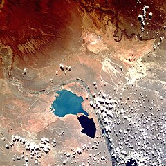
English: Shuttle image of "Cerros Colorados Complex", province of Neuquén, Argentina, March 1990
|
| Dato | |
| Fonto | http://eol.jsc.nasa.gov/sseop/EFS/photoinfo.pl?PHOTO=STS036-80-62 |
| Aŭtoro | Image Science & Analysis Laboratory, NASA Johnson Space Center |
| Pozicio de la fotilo | | Tiu cxi bildo kaj pliaj sur OpenStreetMap |
|---|
This image or video was catalogued by Johnson Space Center of the United States National Aeronautics and Space Administration (NASA) under Photo ID: STS036-80-62. This tag does not indicate the copyright status of the attached work. A normal copyright tag is still required. See Commons:Licensing. Other languages:
|
Permesiloj:
This file is in the public domain in the United States because it was created by the Image Science & Analysis Laboratory, of the NASA Johnson Space Center. NASA copyright policy states that "NASA material is not protected by copyright unless noted". (NASA media use guidelines or Conditions of Use of Astronaut Photographs).
Photo source: STS036-80-62.
|
Dosierhistorio
Alklaku iun daton kaj horon por vidi kiel la dosiero tiam aspektis.
| Dato/Horo | Bildeto | Grandecoj | Uzanto | Komento | |
|---|---|---|---|---|---|
| nun | 15:38, 7 aŭg. 2013 | | 5 237 × 5 237 (8,8 MB) | Ras67 | high resolution |
| 18:49, 26 okt. 2007 |  | 640 × 640 (180 KB) | Denniss | ||
| 20:16, 15 feb. 2007 |  | 600 × 600 (103 KB) | Rosarinagazo | Shuttle image of "Cerros Colorados Complex", province of Chubut, Argentina Author: NASA http://en.wikipedia.org/wiki/Image:Cerros_colorados_res.jpg Category:Dams |
Dosiera uzado
La jena paĝo ligas al ĉi tiu dosiero:
Suma uzado de la dosiero
La jenaj aliaj vikioj utiligas ĉi tiun dosieron:
- Uzado en de.wikipedia.org
- Uzado en en.wikipedia.org
- Uzado en es.wikipedia.org
- Uzado en fr.wikipedia.org
- Uzado en gl.wikipedia.org
- Uzado en lt.wikipedia.org
- Uzado en no.wikipedia.org
- Uzado en uk.wikipedia.org
- Uzado en www.wikidata.org
- Uzado en zh.wikipedia.org