Dosiero:Chaldea - Map - The Countries around Chaldea.png
Jen estas la maksimuma distingivo de la supra bildo.
Chaldea_-_Map_-_The_Countries_around_Chaldea.png ((632 × 458 rastrumeroj, grandeco de dosiero: 75 KB, MIME-tipo: image/png))
| Jen dosiero de la Wikimedia-Komunejo. La priskribo en ties priskriba paĝo estas montrata suben.
|
Resumo
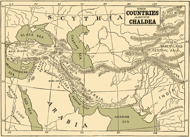
| Priskribo |
English: Map entitled The Countries around Chaldea |
| Dato | |
| Fonto | The Project Gutenberg eBook, Chaldea. http://www.gutenberg.org/files/24654/24654-h/24654-h.htm |
| Aŭtoro | Zénaïde A. Ragozin. No Map Credit. Publisher T. FISHER UNWIN, PATERNOSTER SQUARE, NEW YORK: G. P. PUTNAM'S SONS. MDCCCXCIII |
Permesiloj:
This media file is in the public domain in the United States. This applies to U.S. works where the copyright has expired, often because its first publication occurred prior to January 1, 1929, and if not then due to lack of notice or renewal. See this page for further explanation.
|
 | |
 |
This image might not be in the public domain outside of the United States; this especially applies in the countries and areas that do not apply the rule of the shorter term for US works, such as Canada, Mainland China (not Hong Kong or Macao), Germany, Mexico, and Switzerland. The creator and year of publication are essential information and must be provided. See Wikipedia:Public domain and Wikipedia:Copyrights for more details.
|
Dosierhistorio
Alklaku iun daton kaj horon por vidi kiel la dosiero tiam aspektis.
| Dato/Horo | Bildeto | Grandecoj | Uzanto | Komento | |
|---|---|---|---|---|---|
| nun | 19:52, 1 aŭg. 2012 | | 632 × 458 (75 KB) | Tagishsimon |
Dosiera uzado
La jena paĝo ligas al ĉi tiu dosiero:
Suma uzado de la dosiero
La jenaj aliaj vikioj utiligas ĉi tiun dosieron:
- Uzado en az.wikipedia.org
- Uzado en ba.wikipedia.org
- Uzado en be.wikipedia.org
- Uzado en el.wikipedia.org
- Uzado en en.wikiversity.org
- Uzado en es.wikipedia.org
- Uzado en eu.wikipedia.org
- Uzado en gl.wiktionary.org
- Uzado en he.wikipedia.org
- Uzado en incubator.wikimedia.org
- Uzado en ja.wikipedia.org
- Uzado en ka.wikipedia.org
- Uzado en mg.wikipedia.org
- Uzado en pl.wiktionary.org
- Uzado en ru.wikipedia.org
- Uzado en tr.wikipedia.org
- Uzado en tt.wikipedia.org
- Uzado en vi.wikipedia.org
- Uzado en war.wikipedia.org