Dosiero:Dione PIA08413.jpg

Bildo en pli alta difino ((6 204 × 3 522 rastrumeroj, grandeco de dosiero: 2,97 MB, MIME-tipo: image/jpeg))
| Jen dosiero de la Wikimedia-Komunejo. La priskribo en ties priskriba paĝo estas montrata suben.
|
Resumo
| Priskribo |
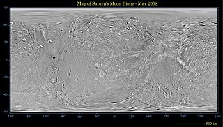
English: This global map of Saturn's moon Dione was created using images taken during Cassini spacecraft flybys, with Voyager images filling in the gaps in Cassini's coverage.
An extensive system of bright ice cliffs created by tectonic fractures adorns the moon's trailing hemisphere. The map is a simple cylindrical (equidistant) projection and has a scale of 614 meters (2,014 feet) per pixel at the equator. The mean radius of Dione used for projection of this map is 562 kilometers (349 miles). This updated map has been shifted west by 0.6 degrees of longitude, compared to the previously released Cassini product (PIA08341), in order to conform to the International Astronomical Union longitude system convention for Dione. The Cassini-Huygens mission is a cooperative project of NASA, the European Space Agency and the Italian Space Agency. The Jet Propulsion Laboratory, a division of the California Institute of Technology in Pasadena, manages the mission for NASA's Science Mission Directorate, Washington, D.C. The Cassini orbiter and its two onboard cameras were designed, developed and assembled at JPL. The imaging operations center is based at the Space Science Institute in Boulder, Colo. |
| Dato | |
| Fonto | http://photojournal.jpl.nasa.gov/catalog/PIA08413 |
| Aŭtoro | NASA/JPL/Space Science Institute |
| Ceteraj versioj | Derivaĵoj de ĉi tiu dosiero: Dione PIA08413 moon only.JPG |
Permesiloj:
| La ĉi-supra dosiero estas publika havaĵo, ĉar ĝi apartenas al NASA. La kopirajta regularo de NASA asertas, ke "ĉiuj dokumentoj de NASA estas publika havaĵo, se ne estas donata kontraŭa deklaro". | ||
 |
Atentu:
|
Dosierhistorio
Alklaku iun daton kaj horon por vidi kiel la dosiero tiam aspektis.
| Dato/Horo | Bildeto | Grandecoj | Uzanto | Komento | |
|---|---|---|---|---|---|
| nun | 22:48, 20 maj. 2008 | | 6 204 × 3 522 (2,97 MB) | Bryan Derksen | {{Information |Description={{en|This global map of Saturn's moon Dione was created using images taken during Cassini spacecraft flybys, with Voyager images filling in the gaps in Cassini's coverage. An extensive system of bright ice cliffs created by tec |
Dosiera uzado
La jena paĝo ligas al ĉi tiu dosiero:
Suma uzado de la dosiero
La jenaj aliaj vikioj utiligas ĉi tiun dosieron:
- Uzado en ca.wikipedia.org
- Uzado en lv.wikipedia.org
- Uzado en pl.wikipedia.org