Dosiero:Fuerstbistum Speyer 1753.jpg

Bildo en pli alta difino ((4 723 × 4 024 rastrumeroj, grandeco de dosiero: 9,97 MB, MIME-tipo: image/jpeg))
| Jen dosiero de la Wikimedia-Komunejo. La priskribo en ties priskriba paĝo estas montrata suben.
|
Resumo
| Priskribo |
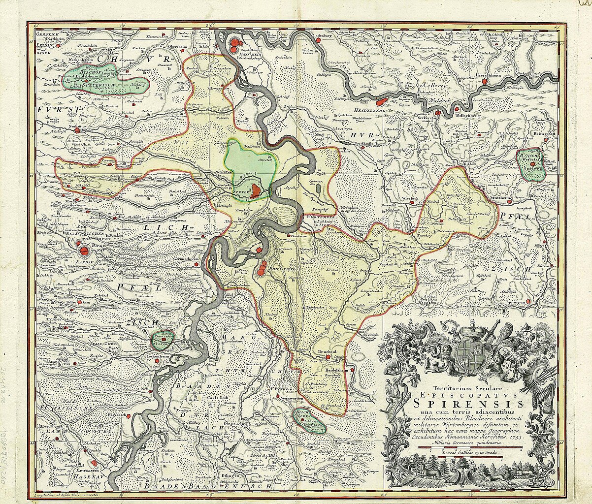
Deutsch: Karte des Fürstbistums Speyer (in gelb, plus vier Exklaven in aqua). Dies ist, wie der Titel der Karte besagt, das weltliche Territorium ("Territorium seculare") des Bischofs und nicht seine Diözese, die größer war. Die Karte zeigt auch das vom Bischof unabhängige Gebiet der Reichsstadt Speyer (hellgrün).
Die Karte wurde von Cyriak Blödner (1672-1733) gezeichnet, einem Militäroffizier, Ingenieur und Kartographen, der während des Spanischen Erbfolgekrieges (1701-1714) an der Planung der Rheinverteidigung beteiligt war. Diese Karte mit dem Titel „Territorium seculare Episcopatus Spirensis“ kam erst ans Licht, als Homanns Erben sie 1753 veröffentlichten. English: Map of the Prince-Bishopric of Speyer (in yellow, plus four exclaves in aqua). This is, as the title of the map indicates, the secular territory ("Territorium seculare") of the bishop, and not his diocese, which was larger. The map also shows the territory of the Imperial city of Speyer (in light green), which was independent of the bishop.
The map was drawn by Cyriak Blödner (1672-1733), a military officer, engineer and cartographer who had been involved in planning the defence of the Rhine during the War of the Spanish Succession (1701-1714). This map, titled Territorium seculare Episcopatus Spirensis, only came to light when Homann's Heirs (Homanns Erben) decided to publish it in 1753. Français : Carte de la principauté épiscopale de Spire (en jaune, plus quatre exclaves couleur aqua). On distingue également le territoire de la ville impériale de Spire (en vert), indépendante de l'évêque. La carte a été dessinée par Cyriak Blödner (1672-1733), officier, ingénieur et cartographe qui avait pris part à la planification de la défense du Rhin durant la Guerre de succession d'Espagne (1701-1714). Cette carte fut seulement publiée en 1753 par les Héritiers d'Homann (Homanns Erben). |
| Fonto | Cyriak Blödner - Homanns Erben 1753 |
| Aŭtoro | Saarlandbilder.net 23:28, 6. Feb. 2008 (CET) |
Permesiloj:
|
Tiu ĉi verko estas publika havaĵo en tiuj landoj, kies kopirajtado validas por longo de vivo plus 70 jaroj aŭ malpli.
| |
| Estis konkludite ke uzon de ĉi tiu dosiero limigas neniu konata aŭtorrajta leĝo, kio inkluzivas ĉiujn rilatajn kaj apudajn rajtojn. | |
Originala alŝutada protokolo
Transigita de de.wikipedia al Commons de Ireas per CommonsHelper.
- 2008-02-06 22:28 Saarlandbilder.net 512×453× (100850 bytes) {{Information |Beschreibung = Karte des Fürstbistums Speyer |Quelle = Homann Heirs 1735 |Urheber = ~~~~ |Datum = |Genehmigung = |Andere Versionen = |Anmerkungen = }}
Dosierhistorio
Alklaku iun daton kaj horon por vidi kiel la dosiero tiam aspektis.
| Dato/Horo | Bildeto | Grandecoj | Uzanto | Komento | |
|---|---|---|---|---|---|
| nun | 12:28, 14 aŭg. 2018 | | 4 723 × 4 024 (9,97 MB) | Lubiesque | Much larger map with better resolution |
| 16:20, 28 sep. 2010 |  | 512 × 453 (98 KB) | File Upload Bot (Magnus Manske) | {{BotMoveToCommons|de.wikipedia|year={{subst:CURRENTYEAR}}|month={{subst:CURRENTMONTHNAME}}|day={{subst:CURRENTDAY}}}} {{Information |Description={{de|Karte des Fürstbistums Speyer}} |Source=Transferred from [http://de.wikipedia.org de.wikipedia]; trans |
Dosiera uzado
La jena paĝo ligas al ĉi tiu dosiero:
Suma uzado de la dosiero
La jenaj aliaj vikioj utiligas ĉi tiun dosieron:
- Uzado en de.wikipedia.org
- Uzado en en.wikipedia.org
- Uzado en es.wikipedia.org
- Uzado en fr.wikipedia.org
- Uzado en it.wikipedia.org
- Uzado en nl.wikipedia.org
- Uzado en pt.wikipedia.org
- Uzado en ru.wikipedia.org