Dosiero:Grid 1811.jpg

Grandeco de ĉi antaŭvido: 208 × 599 rastrumeroj. Alia distingivo: 250 × 720 rastrumeroj.
Bildo en pli alta difino ((250 × 720 rastrumeroj, grandeco de dosiero: 132 KB, MIME-tipo: image/jpeg))
| Jen dosiero de la Wikimedia-Komunejo. La priskribo en ties priskriba paĝo estas montrata suben.
|
Resumo
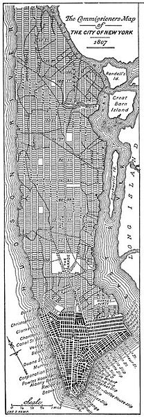
| Priskribo | The Commissioners' Plan of 1811 provisional map, released in 1807 |
| Dato | |
| Fonto | English Wikipedia |
| Aŭtoro | Jleon |
| Permeso (Reuzo de la dosiero) |
The two-dimensional work of art depicted in this image is in the public domain in the United States, either because it was first published in 1922 or earlier, or for the reason described either above or below this message. This photograph of the work is also in the public domain in the United States (see Bridgeman Art Library v. Corel Corp.). Note: Unless the creator died more than 70 years ago, the work of art is not public domain worldwide. It is still, however, usable on the English Wikipedia, because the servers it uses are located in the United States. This information (Creator, death date, etc) should always be listed if known. |
| Ceteraj versioj |
|

Permesiloj:
This work is in the public domain in the United States because it was published (or registered with the U.S. Copyright Office) before January 1, 1929.
Public domain works must be out of copyright in both the United States and in the source country of the work in order to be hosted on the Commons. If the work is not a U.S. work, the file must have an additional copyright tag indicating the copyright status in the source country.
Note: This tag should not be used for sound recordings. |
Dosierhistorio
Alklaku iun daton kaj horon por vidi kiel la dosiero tiam aspektis.
| Dato/Horo | Bildeto | Grandecoj | Uzanto | Komento | |
|---|---|---|---|---|---|
| nun | 11:53, 30 mar. 2007 | 250 × 720 (132 KB) | Jonathan71 | {{Information |Description=The Commissioners' Plan of 1811 provisional map, released in 1807 |Source=English Wikipedia |Date=21 April 2005 |Author=Jleon |Permission=The two-dimensional work of art depicted in this image is in the public domain in the Un |
Dosiera uzado
La jena paĝo ligas al ĉi tiu dosiero:
Suma uzado de la dosiero
La jenaj aliaj vikioj utiligas ĉi tiun dosieron:
- Uzado en ca.wikipedia.org
- Uzado en cs.wikipedia.org
- Uzado en de.wikipedia.org
- Uzado en en.wikipedia.org
- Uzado en en.wikibooks.org
- Uzado en es.wikipedia.org
- Uzado en eu.wikipedia.org
- Uzado en fa.wikipedia.org
- Uzado en fi.wikipedia.org
- Uzado en fr.wikipedia.org
- Uzado en he.wikipedia.org
- Uzado en ja.wikipedia.org
- Uzado en ka.wikipedia.org
- Uzado en nl.wikipedia.org
- Uzado en pt.wikipedia.org
- Uzado en ru.wikipedia.org
- Uzado en uk.wikipedia.org
- Uzado en www.wikidata.org