Dosiero:Han Civilisation bright large.jpg

Bildo en pli alta difino ((2 640 × 1 950 rastrumeroj, grandeco de dosiero: 1,06 MB, MIME-tipo: image/jpeg))
| Jen dosiero de la Wikimedia-Komunejo. La priskribo en ties priskriba paĝo estas montrata suben.
|
| Ĉi tio estas modifita bildo, kio signifas, ke ĝi ekestis per cifereca aliigo de la origina versio. Modifoj: brighter.
|

|
Tiu ĉi bildo historical map respektive ĉiuj bildoj en tiu ĉi artikolo aŭ kategorio prefere estu rekreata(j) kiel vektora grafikaĵo en la formato SVG. Vektoraj formatoj por grafikaĵoj havas multajn avantaĝojn, detaloj troveblas anglalingve en la komuneja artikolo Commons:Media for cleanup. Se vi havas aŭ kreas SVG-version de tiu ĉi bildo, bonvolu alŝuti ĝin al la vikipedia komunejo. Post tiu ago, ĉi tiu ŝablono en la bildpaĝo estas anstataŭigenda per la ŝablono {{vector version available|nova dosiera nomo.svg}}.
|


|
| Priskribo |
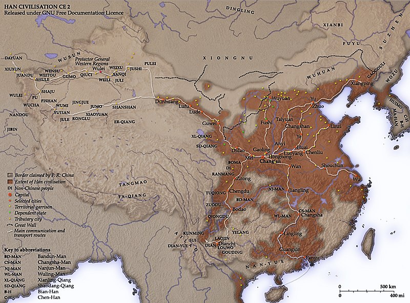
This map shows the world as was known to the Western Han Dynasty (206 BCE – 9 CE) China in 2 CE. The shaded areas show the extent of Han civilisation (206 BCE – 220 CE). Notes
Territorial garrisonsThe headquarters of chief commandants (都尉) are shown in yellow. Chief commandants commanded territorial garrisons and were responsible for the supression of local armed threats and supervision of recruitment for military service.
The Great WallDuring most of the Western Han period, the en:Great Wall served as a line of demarcation between Han and non-Chinese peoples, most notable of whom were the en:Xiongnu. The line of the Great Wall was extended by Emperor Wu along the en:Gansu corridor (the commanderies based at Dunhuang, Lufu, Lude and Guzang). This, along with walls north of the great loop of the en:Yellow River (beyond Wuyuan), provided the front line defences against the Xiongnu. A second line was maintained along the old Qin wall (the one that passes close to Fushi and Didao), which was important even into the en:1st century. Both the lines of the Great Wall and Yellow River are based on Tan Qixiang (ed.), Zhongguo lishi ditu (中国历史地图集; 1982). Note that the Yellow River is considerably to the north of its present flow. Routes of communicationThe broad outline of communication and transport routes from the capital en:Chang'an is marked in white. These were based on en:Qin Dynasty imperial highways, Han roads (such as the Chang'an-Anyi-Taiyuan-Yu road) and navigable riverways (such as the Chenliu and Shouchun route). The long road extending west from Chang'an to the "en:Western Regions" is often known as the en:Silk Road. These are based in part on the reconstruction of early Chinese roads and waterways by en:Joseph Needham in Science and Civilisation, Vol. IV, (1954), and the additions of en:Rafe de Crespigny in Generals of the South (1992). The northern and southern routes of the Silk Road in the Western Regions is based on Map 16 in Cambridge History of China, vol. 1, (1986). The Western RegionsFrom the end of the en:2nd century BC, Han China fought with the Xiongnu over control of the Western Regions. By the time that they established the office of Protector General of the Western Regions (at Wulei) in en:60 BC or en:59 BC, the entire region was dominated by the Chinese. Tributary city-states, in light orange, sent periodic tribute to Chang'an and were rewarded by the Han court. TransliterationNames of non-Chinese peoples and states have been purposely left with their Chinese names (e.g. Dayuan instead of en:Fergana; Gaogouli instead of en:Goguryeo) to reflect the fact that our knowledge of participants in the Han world order comes almost exclusively from Chinese sources. Chinese names are transliterated by en:pinyin (e.g. Dayuan instead of Ta-yuan). Transliteration of non-Chinese peopes and states follows the pronunciation guides given in the Hou Han shu. They often diverge from the Mandarin pronunciations which are now standard: 婼羌 Er-Qiang; 鄯善 Shanshan; 且末 Jumo; 小宛 Xiao-Yuan; 精絕 Jingjue; 戎盧 Ronglu; 扜彌 Wumi; 渠勒 Jule; 于闐 Yutian; 皮山 Pishan; 烏秅 Wucha; 西夜 Xiye (Xiyi); 蒲 Pu; 依耐 Yinai; 無雷 Wulei; 難兜 Nandou; 罽賓 Jibin; 烏弋山離 Wuyishanli; 安息 Anxi; 大月氏 Da-Yuezhi; 康居 Kangju; 大宛 Da-Yuan; 桃槐 Taohui; 休循 Xiuxun; 捐毒 Juandu; 莎車 Shaju; 疏勒 Shule; 尉頭 Weitou; 龜茲 Qiuci; 姑墨 Gumo; 焉耆 Yanqi. Related images
|
||||||||
| Dato | |||||||||
| Fonto | Own work compiled from and based on the sources stated above | ||||||||
| Aŭtoro | User Yeu Ninje on en.wikipedia | ||||||||
| Permeso (Reuzo de la dosiero) |
Yeu Ninje de la anglalingva Vikipedio, la posedanto de la aŭtorrajto por ĉi tiu verko, ĉi-maniere publikigas tiun laŭ la jena permesilo:
|
||||||||
| Ceteraj versioj |
Originally from en.wikipedia; description page is (was) here * 21:06, 14 June 2006 [[:en:User:Yeu Ninje|Yeu Ninje]] 880×650 (1,051,992 bytes) <span class="comment">(Border of P. R. China --> Border claimed by P. R. China.)</span> * 12:44, 1 March 2006 [[:en:User:Yeu Ninje|Yeu Ninje]] 880×650 (1,054,864 bytes) <span class="comment">(more small changes.)</span> * 01:07, 26 February 2006 [[:en:User:Yeu Ninje|Yeu Ninje]] 880×650 (1,052,476 bytes) * 21:53, 25 February 2006 [[:en:User:Yeu Ninje|Yeu Ninje]] 880×650 (919,134 bytes) <span class="comment">(Created and copyright (2006) by [[:en:Yeu Ninje]]. Released under the [[:en:GNU FDL]].)</span> |


Category:Files by User:Yeu Ninje from en.wikipedia (Uploaded using CommonsHelper or PushForCommons)
Dosierhistorio
Alklaku iun daton kaj horon por vidi kiel la dosiero tiam aspektis.
| Dato/Horo | Bildeto | Grandecoj | Uzanto | Komento | |
|---|---|---|---|---|---|
| nun | 18:05, 28 nov. 2009 | | 2 640 × 1 950 (1,06 MB) | Papa Lima Whiskey | {{retouched|brighter}} {{SVG|map}} {{Assessments|enwiki=1}} {{Information| |Description= __NOTOC__ == Notes == Created and copyright (2006) by Yeu Ninje. Released under the GNU FDL. This map |
Dosiera uzado
La jena paĝo ligas al ĉi tiu dosiero:
Suma uzado de la dosiero
La jenaj aliaj vikioj utiligas ĉi tiun dosieron:
- Uzado en en.wikipedia.org
- Uzado en ky.wikipedia.org