Dosiero:Ireland (4440319873).jpg

Bildo en pli alta difino ((1 600 × 2 200 rastrumeroj, grandeco de dosiero: 478 KB, MIME-tipo: image/jpeg))
| Jen dosiero de la Wikimedia-Komunejo. La priskribo en ties priskriba paĝo estas montrata suben.
|
.jpg)
Resumo
| Priskribo |
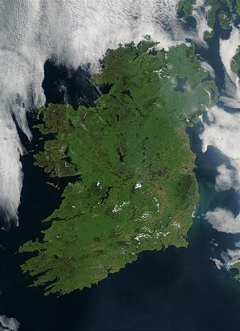
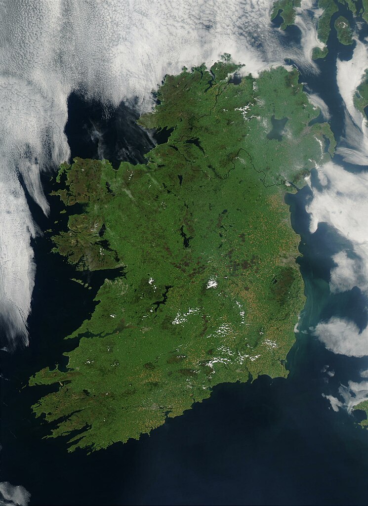
On August 7, 2003, the NASA Aqua MODIS instrument acquired this image of Ireland on the first day this summer that most of the island hasn´t been completely obscured by cloud cover. Called the Emerald Isle for a good reason, Ireland is draped in vibrant shades of green amidst the blue Atlantic Ocean and Celtic (south) and Irish (east) Seas. Faint ribbons of blue-green phytoplankton drift in the waters of the Celtic Sea, just south of Dublin. Dublin itself appears as a large grayish-brown spot on the Republic of Ireland´s northeastern coast. This large capital city (population 1.12 million) sits on the River Liffey, effectively splitting the city in half. Northern Ireland´s capital city, Belfast, also sits on a river: the River Lagan. This city, though its population is only a fifth of the size of Dublin´s, is also clearly visible in the image as a grayish-brown spot on the coast of the Irish Sea. Sensor Aqua/MODIS Credit Jeff Schmaltz, MODIS Rapid Response Team, NASA/GSFC
<a href="http://visibleearth.nasa.gov/view_rec.php?id=5744" rel="nofollow">visibleearth.nasa.gov/view_rec.php?id=5744</a>
Follow us on Twitter Join us on <a href="http://www.facebook.com/pages/Greenbelt-MD/NASA-Goddard/395013845897?ref=tsd" rel="nofollow">Facebook</a> |
| Dato | |
| Fonto | Ireland |
| Aŭtoro | NASA Goddard Space Flight Center from Greenbelt, MD, USA |
| Pozicio de la fotilo | | Tiu cxi bildo kaj pliaj sur OpenStreetMap |
|---|
.jpg¶ms=052.802761_N_-007.910156_E_globe:Earth_type:camera_source:Flickr_&language=eo)
Permesiloj:
- Vi rajtas:
- kunhavigi – kopii, distribui kaj publikigi la verkon
- aliigi – modifi, adapti, kompletigi, transformi, uzi la tutan verkon aŭ ties partojn, memstare aŭ en aliaj verkoj
- La verko rajtas esti kunhavigata nur:
- atribuite – Vi devas atribui aŭtorecon, liveri ligilon al la permesilo kaj marki ĉu ŝanĝoj estis faritaj. Faru tion en aprobinda maniero, tamen ne sugestante, ke permesinto aprobas vin aŭ vian uzon.
| This image was originally posted to Flickr by NASA Goddard Photo and Video at https://flickr.com/photos/24662369@N07/4440319873 (archive). It was reviewed on la 11-a de majo 2018 by FlickreviewR 2 and was confirmed to be licensed under the terms of the cc-by-2.0. |
| La ĉi-supra dosiero estas publika havaĵo, ĉar ĝi apartenas al NASA. La kopirajta regularo de NASA asertas, ke "ĉiuj dokumentoj de NASA estas publika havaĵo, se ne estas donata kontraŭa deklaro". | ||
 |
Atentu:
|
Dosierhistorio
Alklaku iun daton kaj horon por vidi kiel la dosiero tiam aspektis.
| Dato/Horo | Bildeto | Grandecoj | Uzanto | Komento | |
|---|---|---|---|---|---|
| nun | 23:48, 11 maj. 2018 | | 1 600 × 2 200 (478 KB) | OceanAtoll | Transferred from Flickr via #flickr2commons |
Dosiera uzado
La jenaj paĝoj ligas al ĉi tiu dosiero:
Suma uzado de la dosiero
La jenaj aliaj vikioj utiligas ĉi tiun dosieron:
- Uzado en nds-nl.wikipedia.org
- Uzado en nl.wikipedia.org
.jpg)