Dosiero:Louisiade archipelago.jpg

Grandeco de ĉi antaŭvido: 800 × 600 rastrumeroj. Aliaj distingivoj: 320 × 240 rastrumeroj | 640 × 480 rastrumeroj | 1 024 × 768 rastrumeroj | 1 280 × 960 rastrumeroj | 2 000 × 1 500 rastrumeroj.
Bildo en pli alta difino ((2 000 × 1 500 rastrumeroj, grandeco de dosiero: 449 KB, MIME-tipo: image/jpeg))
| Jen dosiero de la Wikimedia-Komunejo. La priskribo en ties priskriba paĝo estas montrata suben.
|
Resumo
| Priskribo |
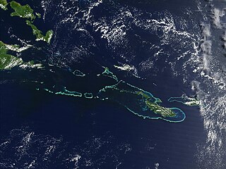
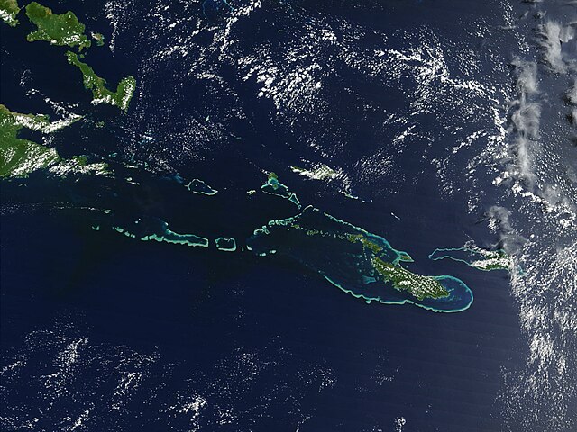
English: Off the southeast tip of Papua New Guinea lies a string of small volcanic islands and coral reefs collectively called the Louisiade Archipelago. This true-color MODIS image from September 11, 2002, is centered on the island chain, with Papua New Guinea at the left edge. Moving westward from eastern end of the chain are the islands of Rossel and Tagula. (Misima Island, which harbors the largest village in the region, is obscured by a patch of clouds northeast of image center.) To the north of the chain lies the Solomon Sea, and to the south is the Coral Sea. Most of the undisturbed land is covered by tropical rainforest, and despite their small size, the islands harbor a number of plant and animal species found nowhere else. |
| Dato | la 7-a de majo 2005 (origina alŝuta dato) |
| Fonto | Transferred from en.wikipedia |
| Aŭtoro | NASA |
Permesiloj:
| La ĉi-supra dosiero estas publika havaĵo, ĉar ĝi apartenas al NASA. La kopirajta regularo de NASA asertas, ke "ĉiuj dokumentoj de NASA estas publika havaĵo, se ne estas donata kontraŭa deklaro". | ||
 |
Atentu:
|
Originala alŝutada protokolo
All following user names refer to en.wikipedia.
- 2005-05-07 02:55 PDH 2000×1500× (459961 bytes) Off the southeast tip of Papua New Guinea lies a string of small volcanic islands and coral reefs collectively called the Louisiade Archipelago. This true-color MODIS image from September 11, 2002, is centered on the island chain, with Papua New Guinea at
Dosierhistorio
Alklaku iun daton kaj horon por vidi kiel la dosiero tiam aspektis.
| Dato/Horo | Bildeto | Grandecoj | Uzanto | Komento | |
|---|---|---|---|---|---|
| nun | 08:55, 18 okt. 2009 | | 2 000 × 1 500 (449 KB) | Urdangaray | {{Information |Description={{en|Off the southeast tip of Papua New Guinea lies a string of small volcanic islands and coral reefs collectively called the Louisiade Archipelago. This true-color MODIS image from September 11, 2002, is centered on the island |
Dosiera uzado
La jena paĝo ligas al ĉi tiu dosiero:
Suma uzado de la dosiero
La jenaj aliaj vikioj utiligas ĉi tiun dosieron:
- Uzado en als.wikipedia.org
- Uzado en ast.wikipedia.org
- Uzado en br.wikipedia.org
- Uzado en ca.wikipedia.org
- Uzado en ceb.wikipedia.org
- Uzado en de.wikipedia.org
- Uzado en en.wikipedia.org
- Uzado en en.wikivoyage.org
- Uzado en es.wikipedia.org
- Uzado en eu.wikipedia.org
- Uzado en he.wikivoyage.org
- Uzado en hy.wikipedia.org
- Uzado en it.wikipedia.org
- Uzado en ka.wikipedia.org
- Uzado en la.wikipedia.org
- Uzado en or.wikipedia.org
- Uzado en pl.wikipedia.org
- Uzado en vi.wikipedia.org
- Uzado en www.wikidata.org