Dosiero:Map of Afghanistan, Districts and Provinces.svg

Grando de tiu PNG antaŭprezento de tiu SVGa dosiero: 750 × 475 rastrumeroj. Aliaj distingivoj: 320 × 203 rastrumeroj | 640 × 405 rastrumeroj | 1 024 × 649 rastrumeroj | 1 280 × 811 rastrumeroj | 2 560 × 1 621 rastrumeroj.
Bildo en pli alta difino (SVG-dosiero, 750 × 475 rastrumeroj, grandeco de dosiero: 2,57 MB)
| Jen dosiero de la Wikimedia-Komunejo. La priskribo en ties priskriba paĝo estas montrata suben.
|
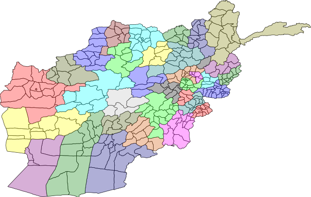
| Priskribo | A map of the districts of Afghanistan. The districts are colour grouped by province. | |||||
| Dato | ||||||
| Fonto |
Map originally from Maplibrary.org who in turn have extracted it from GADM version 0.9 which source the data for Afghanistan as comming from the USGS.
|
|||||
| Aŭtoro | USGS and Lokal_Profil | |||||
| Permeso (Reuzo de la dosiero) |
|
|||||
| Ceteraj versioj |
|


Dosierhistorio
Alklaku iun daton kaj horon por vidi kiel la dosiero tiam aspektis.
| Dato/Horo | Bildeto | Grandecoj | Uzanto | Komento | |
|---|---|---|---|---|---|
| nun | 20:31, 1 mar. 2009 | | 750 × 475 (2,57 MB) | Lokal Profil | {{Information |Description=A map of the districts of Afghanistan. The districts are colour grouped by province. |Source=Map originally from [http://www.maplibrary.org/stacks/gadm/AFG/index.php Maplibrary.org] who in turn have extracted it from [http://bio |
Dosiera uzado
La jena paĝo ligas al ĉi tiu dosiero:
Suma uzado de la dosiero
La jenaj aliaj vikioj utiligas ĉi tiun dosieron:
- Uzado en de.wikipedia.org
- Uzado en he.wikipedia.org
- מחוזות אפגניסטן
- קונדוז (מחוז)
- תבנית:מחוזות אפגניסטן
- הראת (מחוז)
- פראה (מחוז)
- גור (מחוז)
- באדגיס
- נימרוז
- הלמנד (מחוז)
- קנדהאר (מחוז)
- אורוזגאן
- דאיכונדי
- ע'זני (מחוז)
- זאבול
- פכתיכא
- מיידאן ורדכ
- באמיאן
- סר-י פול (מחוז)
- פאריאב
- בלח' (מחוז)
- סמנגאן
- בגלאן (מחוז)
- תח'אר
- פרוואן
- ח'וסת (מחוז)
- פכתיא
- ג'וזג'אן
- לוגר (מחוז)
- כאפיסא
- ננגרהאר
- לגמאן
- קאבול (מחוז)
- כונר
- נורסתאן
- פנג'שיר
- בדח'שאן
- Uzado en hi.wikipedia.org
Vidi plian ĝeneralan uzadon de ĉi tiu dosiero.