Dosiero:Map of Attica and Megaris.jpg
Bildo en pli alta difino ((3 895 × 2 769 rastrumeroj, grandeco de dosiero: 6,9 MB, MIME-tipo: image/jpeg))
| Jen dosiero de la Wikimedia-Komunejo. La priskribo en ties priskriba paĝo estas montrata suben.
|
| Priskribo |
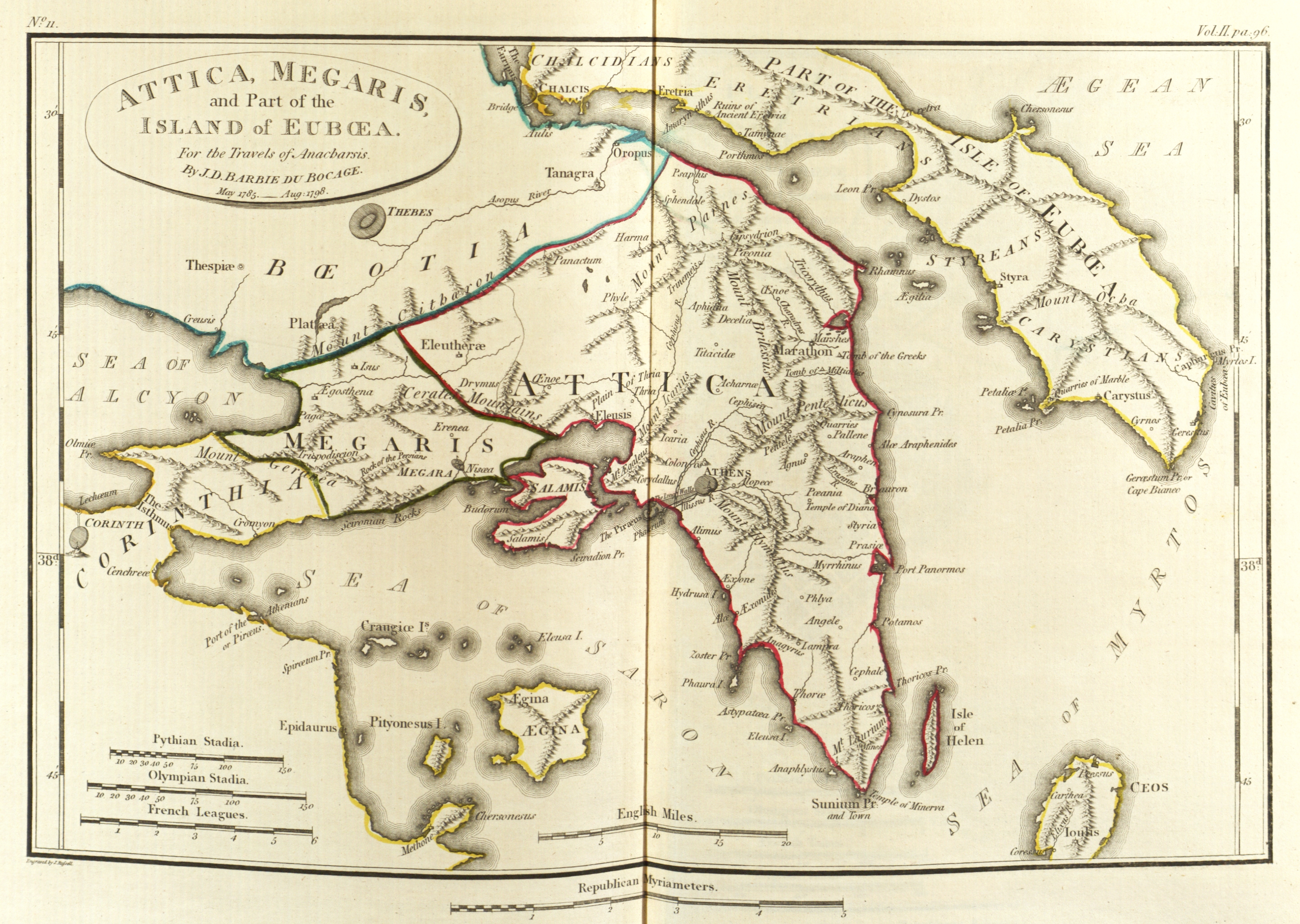
English: Scan of Map of Attica and Megaris.
|
|||||||
| Dato | ||||||||
| Fonto | Maps, plans, views and coins illustrative of the travels of Anacharsis the Younger in Greece, during the middle of the fourth century before the Christian era | |||||||
| Aŭtoro | J. J. Barthélemy | |||||||

Dosierhistorio
Alklaku iun daton kaj horon por vidi kiel la dosiero tiam aspektis.
| Dato/Horo | Bildeto | Grandecoj | Uzanto | Komento | |
|---|---|---|---|---|---|
| nun | 01:38, 24 maj. 2010 | | 3 895 × 2 769 (6,9 MB) | Aremulus | {{Information |Description={{en|1=Scan of Map of Attica and Megaris. {{PD-1923}} {{PD-self}} {{PD-old}} {{PD-scan}}}} |Source=Maps, plans, views and coins illustrative of the travels of Anacharsis the Younger in Greece, during the middle of the fourth ce |
Dosiera uzado
La jena paĝo ligas al ĉi tiu dosiero:
Suma uzado de la dosiero
La jenaj aliaj vikioj utiligas ĉi tiun dosieron:
- Uzado en am.wikipedia.org
- Uzado en bg.wikipedia.org
- Uzado en en.wikipedia.org
- Paeania
- Colonus (Attica)
- Megaris
- Pentele
- Ancyle
- Corydallus
- Tetrapolis (Attica)
- Oenoe (Attica)
- Anagyrous
- Erchia
- Angele (deme)
- Thriasio Plain
- Cephisia
- Cydathenaeum
- Pandionis
- Cephale
- Diacria
- Araphen
- Halae Araphenides
- Amphitrope
- Atene (deme)
- Anaphlystus
- Phrearrhii
- Mesogeia
- Paralia (Attica)
- Iphistiadae
- Alope (spring)
- Oenoe (Marathon)
- Tricorythus
- Trinemeia
- Xypete
- Thymoetadae
- Echelidae
- Hermus (Attica)
- Oea (Attica)
- Oeum Cerameicum
- Oeum Deceleicum
- Scirum
- Laciadae
- Eupyridae
- Cropia (Attica)
- Peleces
- Paeonidae
- Leipsydrium
- Athmonum
- Eiresidae
- Gargettus
- Hagnus (Attica)
Vidi plian ĝeneralan uzadon de ĉi tiu dosiero.