Dosiero:Map of Sealand with territorial waters.png

Bildo en pli alta difino((1 174 × 1 200 rastrumeroj, grandeco de dosiero: 55 KB, MIME-tipo: image/png))

Jen dosiero de la Wikimedia-Komunejo. La priskribo en ties priskriba paĝo estas montrata suben.
La Komunejo estas dosieruja retejo de libere licencitaj dosieroj.
Priskribo

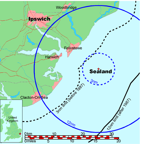
Map of Sealand

This is a map of the coast of England near Ipswich, showing the location of Sealand. The boundaries of the territorial water of the United Kingdom are also drawn, both the 3 nautical mile limit (5.556km) before 1987 and the 12nm limit (22.22km) after 1987. The same radii are also given around Sealand.

Note that these boundaries are derived based on the circular distance from the coastline, and not copied from official maps. This map is not suitable for navigation or for determining the boundaries of the UK territorial waters for legal or other purposes.

Kreinto
Map generated by DEMIS World Map Server and edited by Chris 73
Permeso
(Reuzo de la dosiero)


Licensing:

This image was created by Chris 73. The image is licensed under a dual license; please choose either of the two licenses below as desired. Attribution to Wikipedia or another project of the Wikimedia foundation is required for both licenses if the image is used outside of projects of the Wikimedia foundation. Attribution to me is not required.

GNU head Estas permesite kopii, disdoni kaj/aŭ redakti ĉi tiun dokumenton, sen senŝanĝaj sekcioj, sen antaŭkovrilaj kaj sen dorskovrilaj tekstoj, laŭ la kondiĉoj de la Permesilo GNU por Liberaj Dokumentoj, Versio 1.3 aŭ ajna pli nova versio eldonita de la Free Software Foundation; sen Senŝanĝaj Sekcioj, Antaŭovrilaj Tekstoj aŭ Malantaŭkovrilaj Tekstoj. Kopio de la permesilo estas inkluzivita en la sekcio titolita GNU Free Documentation License.

w:eo:Creative Commons
atribuite samkondiĉe
Ĉi tiu dosiero estas disponebla laŭ la permesilo Krea Komunaĵo Atribuite-Samkondiĉe 3.0 Neadaptita.
Vi rajtas:
  • kunhavigi – kopii, distribui kaj publikigi la verkon
  • aliigi – modifi, adapti, kompletigi, transformi, uzi la tutan verkon aŭ ties partojn, memstare aŭ en aliaj verkoj
La verko rajtas esti kunhavigata nur:
  • atribuite – Vi devas atribui aŭtorecon, liveri ligilon al la permesilo kaj marki ĉu ŝanĝoj estis faritaj. Faru tion en aprobinda maniero, tamen ne sugestante, ke permesinto aprobas vin aŭ vian uzon.
  • samkondiĉe – Se vi rekombinas la verkon, transformas ĝin aŭ kreas devenaĵon bazitan sur ĝi, vi rajtas distribui la rezultan verkon nur laŭ la sama aŭ kongrua permesilo kompare kun ĉi tiu.

"I want to use the image. How do I do that?"

You can use this image freely for any purpose, including commercial use, provided that you license it under one of the above licenses. My suggestion is to use the following text:

This Wikipedia and Wikimedia Commons image is from the user Chris 73 and is freely available at //commons.wikimedia.org/wiki/File:Map_of_Sealand_with_territorial_waters.png under the creative commons cc-by-sa 3.0 license.

For privacy reasons please use only "Chris 73" as author. If necessary, please translate the text in your language. For electronic use please include the links in the text as shown, for printed use please print the text as shown. If you use the image I would appreciate it if you would let me know on my talk page, but this is not required as long as you follow one of the above licenses.


 Geotemporal data
Bounding box
N: 52.1374339°N
W: 0.9973602°E E: 1.6619722°E
S: 51.6274989°N
Georeferencing View the georeferenced map in the Wikimaps Warper

Titoloj

Donu unulinian priskribon de la enhavo de ĉi tiu dosiero

Eroj prezentitaj en ĉi tiu dosiero

montras

image/png

845a9e08cbe7ed93bae6eeabe454399a76e3324f

56 131 bajto

1 200 rastrumero

1 174 rastrumero

Dosierhistorio

Alklaku iun daton kaj horon por vidi kiel la dosiero tiam aspektis.

Dato/HoroBildetoGrandecojUzantoKomento
nun19:41, 9 jul. 2006Bildeto por versio ekde 19:41, 9 jul. 20061 174 × 1 200 (55 KB)Chris 73update
10:00, 26 jan. 2005Bildeto por versio ekde 10:00, 26 jan. 20051 024 × 1 046 (50 KB)Chris 73

La jena paĝo ligas al ĉi tiu dosiero:

Suma uzado de la dosiero

La jenaj aliaj vikioj utiligas ĉi tiun dosieron: