Bildo en pli alta difino((2 180 × 1 244 rastrumeroj, grandeco de dosiero: 2,33 MB, MIME-tipo: image/jpeg))

Jen dosiero de la Wikimedia-Komunejo. La priskribo en ties priskriba paĝo estas montrata suben.
La Komunejo estas dosieruja retejo de libere licencitaj dosieroj.

Resumo

Priskribo
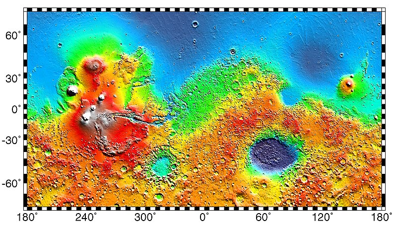
English: PIA02031: Maps of Mars Global Topography - Maps of Mars' global topography. The projections are Mercator to 70° latitude and stereographic at the poles with the south pole at left and north pole at right. Note the elevation difference between the northern and southern hemispheres. The Tharsis volcano-tectonic province is centered near the equator in the longitude range 220° E to 300° E and contains the vast east-west trending Valles Marineris canyon system and several major volcanic shields including Olympus Mons (18° N, 225° E), Alba Patera (42° N, 252° E), Ascraeus Mons (12° N, 248° E), Pavonis Mons (0°, 247° E), and Arsia Mons (9° S, 239° E). Regions and structures discussed in the text include Solis Planum (25° S, 270° E), Lunae Planum (10° N, 290° E), and Claritas Fossae (30° S, 255° E). Major impact basins include Hellas (45° S, 70° E), Argyre (50° S, 320° E), Isidis (12° N, 88° E), and Utopia (45° N, 110° E). This analysis uses an areocentric coordinate convention with east longitude positive.

Color coding on this map of the planet Mars indicates relative elevations based on data from the Mars Orbiter Laser Altimeter on NASA's Mars Global Surveyor. Red is higher elevation (up to +8 km and higher); yellow is 0 km; blue is lower elevation (down to -8 km). In longitude, the map extends from 70 degrees (north) to minus 70 degrees (south). The east-west axis is labeled at the bottom in degrees of east longitude, with the zero meridian at the center.

Data was produced by the Mars Global Surveyor's MOLA instrument

  • Producer ID: P50409 MRPS95009
Português: Mapa de Marte.
Русский: Карта Марса.
Dato (released)
Fonto http://photojournal.jpl.nasa.gov/catalog/PIA02031 (image link)
Aŭtoro NASA/JPL/GSFC
Permeso
(Reuzo de la dosiero)
https://www.jpl.nasa.gov/imagepolicy/
Ceteraj versioj

Related Templates:

Related Images:

This image or video was catalogued by Jet Propulsion Laboratory of the United States National Aeronautics and Space Administration (NASA) under Photo ID: PIA02031.

This tag does not indicate the copyright status of the attached work. A normal copyright tag is still required. See Commons:Licensing.
Other languages:

Permesiloj:

Public domain La ĉi-supra dosiero estas publika havaĵo, ĉar ĝi apartenas al NASA. La kopirajta regularo de NASA asertas, ke "ĉiuj dokumentoj de NASA estas publika havaĵo, se ne estas donata kontraŭa deklaro".
Atentu:

Originala alŝutada protokolo

The original description page was here. All following user names refer to en.wikipedia.
  • 2012-10-26 05:43 Kelvin Case 613×350× (142399 bytes) {{Information |Description= {{en|Map of mars.}} {{pt|Mapa de Marte.}} http://photojournal.jpl.nasa.gov/catalog/PIA02031 PIA02031: Maps of Mars Global Topography Target Name:Mars Is a satellite of:Sol (our sun) Mission: Mars Global Surveyor (MGS) ...

Titoloj

Donu unulinian priskribon de la enhavo de ĉi tiu dosiero

Eroj prezentitaj en ĉi tiu dosiero

montras

Dosierhistorio

Alklaku iun daton kaj horon por vidi kiel la dosiero tiam aspektis.

Dato/HoroBildetoGrandecojUzantoKomento
nun02:57, 4 maj. 2019Bildeto por versio ekde 02:57, 4 maj. 20192 180 × 1 244 (2,33 MB)HuntsterFull resolution from NASA/JPL.
09:23, 6 maj. 2014Bildeto por versio ekde 09:23, 6 maj. 2014613 × 350 (139 KB)Wikiuser13Transferred from en.wikipedia

La jena paĝo ligas al ĉi tiu dosiero:

Suma uzado de la dosiero

Metadatumoj