Dosiero:Militargrenze, Wojwodowena und Banat.jpg
Bildo en pli alta difino ((900 × 312 rastrumeroj, grandeco de dosiero: 115 KB, MIME-tipo: image/jpeg))
| Jen dosiero de la Wikimedia-Komunejo. La priskribo en ties priskriba paĝo estas montrata suben.
|
| Priskribo |
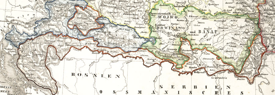
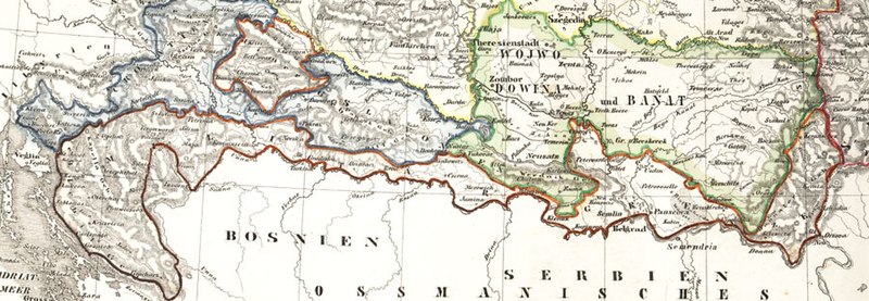
Deutsch: Karte der österreichischen Militärgrenze aus dem 19. Jahrhundert.
English: Historic map of the military frontier of Austria-Hungary, also named Krajina, and of Vojvodina
Français : Carte historique des confins militaires en Autriche-Hongrie aussi appelé Krajina |
||||
| Dato | 2004 | ||||
| Fonto | de:Bild:Militärgrenze.jpg | ||||
| Aŭtoro | Scan plp | ||||
| Permeso (Reuzo de la dosiero) |
|
||||
| Ceteraj versioj |
 |
||||
| Annotations | This image is annotated: View the annotations at Commons |
Dosierhistorio
Alklaku iun daton kaj horon por vidi kiel la dosiero tiam aspektis.
| Dato/Horo | Bildeto | Grandecoj | Uzanto | Komento | |
|---|---|---|---|---|---|
| nun | 04:57, 26 sep. 2008 | 900 × 312 (115 KB) | Nikola Smolenski | {{Information |Description={{de|Karte der österreichischen de:Militärgrenze aus dem 19. Jahrhundert.}} {{en|Historic map of the military frontier of Austria-Hungary, also named w:Krajina, and of w:Vojvodina}} {{fr|Carte historique des con |
Dosiera uzado
La jenaj paĝoj ligas al ĉi tiu dosiero:
Suma uzado de la dosiero
La jenaj aliaj vikioj utiligas ĉi tiun dosieron:
- Uzado en azb.wikipedia.org
- Uzado en be-tarask.wikipedia.org
- Uzado en bg.wikipedia.org
- Uzado en bs.wikipedia.org
- Uzado en cs.wikipedia.org
- Uzado en da.wikipedia.org
- Uzado en de.wikipedia.org
- Uzado en en.wikipedia.org
- Uzado en es.wikipedia.org
- Uzado en et.wikipedia.org
- Uzado en fa.wikipedia.org
- Uzado en fr.wikipedia.org
- Uzado en gl.wikipedia.org
- Uzado en hr.wikipedia.org
- Uzado en hu.wikipedia.org
- Uzado en id.wikipedia.org
- Uzado en it.wikipedia.org
- Uzado en ja.wikipedia.org
- Uzado en ko.wikipedia.org
- Uzado en mk.wikipedia.org
Vidi plian ĝeneralan uzadon de ĉi tiu dosiero.