Dosiero:NintokuTomb.jpg

Grandeco de ĉi antaŭvido: 600 × 600 rastrumeroj. Aliaj distingivoj: 240 × 240 rastrumeroj | 480 × 480 rastrumeroj | 769 × 768 rastrumeroj | 1 025 × 1 024 rastrumeroj | 1 345 × 1 344 rastrumeroj.
Bildo en pli alta difino ((1 345 × 1 344 rastrumeroj, grandeco de dosiero: 2,38 MB, MIME-tipo: image/jpeg))
| Jen dosiero de la Wikimedia-Komunejo. La priskribo en ties priskriba paĝo estas montrata suben.
|
| Priskribo |
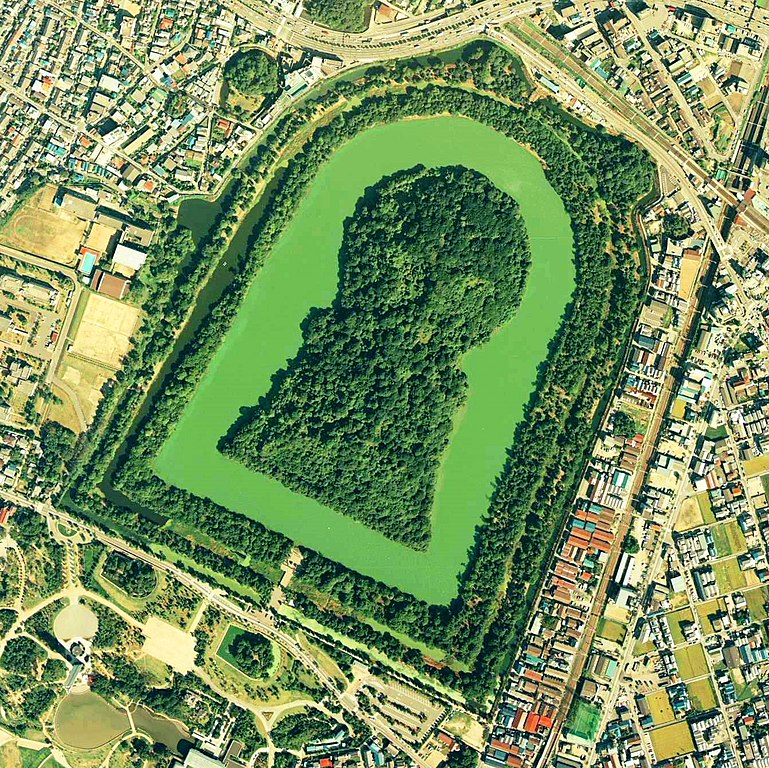
Daisen-kofun in Sakai, Osaka, Japan. This is one of the largest tombs in the world. Japanese government regards this as the tomb of Emperor Nintoku, the 16th emperor, but many historians don't think so. The keyhole-like tomb is 486m long, 305m wide at the bottom and 245m in diameter. English: Daisen-Kofun, the tomb of Emperor Nintoku, Osaka
Español: El Daisen-Kofun, tumba legendaria de Emperador Nintoku
Suomi: Kofun-kauden hautakumpu Osakassa, yksi maailman suurimmista. |
| Dato | |
| Fonto | http://w3land.mlit.go.jp/cgi-bin/WebGIS2/WC_AirPhoto.cgi?IT=p&DT=n&PFN=CKK-85-2&PCN=C2&IDX=8 |
| Aŭtoro | Ministry of Land, Infrastructure and Transport Government of Japan & moja resized |
| Permeso (Reuzo de la dosiero) |
GFDL |
| Pozicio de la fotilo | | Tiu cxi bildo kaj pliaj sur OpenStreetMap |
|---|
- 仁徳天皇陵とされる古墳
- ソース
- 整理番号:CKK852-C2-8
- 撮影:1985年(昭和60年)

|
La posedanto de la aŭtorrajto por ĉi tiu dosiero, the Ministry of Land, Infrastructure, Transport and Tourism of Japan, permesas al ĉiu ajn utiligi ĝin por ia ajn kialo, se la posedanto de la aŭtorrajto estas bone atributita. Redistribuado, deriva verkado, komerca uzado, kaj ĉiuj aliaj uzoj estas permesitaj. |
Atribuite:
Copyright © National Land Image Information (Color Aerial Photographs), Ministry of Land, Infrastructure, Transport and Tourism
|
 |
This image is copyrighted by the Ministry of Land, Infrastructure, Transport and Tourism of Japan. For terms of use, see the stipulation to use of National Land Information (in Japanese) and message from MLIT (in Japanese and English). When you display this image on an article, include the following phrase in the description: "Made based on National Land Image Information (Color Aerial Photographs), Ministry of Land, Infrastructure, Transport and Tourism".
|
Dosierhistorio
Alklaku iun daton kaj horon por vidi kiel la dosiero tiam aspektis.
| Dato/Horo | Bildeto | Grandecoj | Uzanto | Komento | |
|---|---|---|---|---|---|
| nun | 09:19, 7 jun. 2020 | | 1 345 × 1 344 (2,38 MB) | 名古屋太郎 | 明るさ等変更 |
| 20:44, 17 aŭg. 2005 |  | 800 × 800 (515 KB) | Moja~commonswiki | {{Information| |Description=Daisen-kofun in Sakai, Osaka, Japan. This is one of the largest tombs in the world. Japanese gorvernment regards this as the tomb of Emperor Nintoku, the 16th emperor, but many historians doubt don't think so. The keyhole-lik |
Dosiera uzado
Neniu paĝo ligas al ĉi tiu dosiero.
Suma uzado de la dosiero
La jenaj aliaj vikioj utiligas ĉi tiun dosieron:
- Uzado en en.wikipedia.org
- Uzado en fr.wikipedia.org
- Uzado en ja.wikipedia.org
- Uzado en www.wikidata.org
- Uzado en zh.wikipedia.org