Dosiero:River Nith estuary.jpg

Grandeco de ĉi antaŭvido: 800 × 533 rastrumeroj. Aliaj distingivoj: 320 × 213 rastrumeroj | 640 × 427 rastrumeroj | 1 024 × 683 rastrumeroj | 1 280 × 853 rastrumeroj | 2 560 × 1 707 rastrumeroj | 3 504 × 2 336 rastrumeroj.
Bildo en pli alta difino ((3 504 × 2 336 rastrumeroj, grandeco de dosiero: 8,68 MB, MIME-tipo: image/jpeg))
| Jen dosiero de la Wikimedia-Komunejo. La priskribo en ties priskriba paĝo estas montrata suben.
|
Resumo
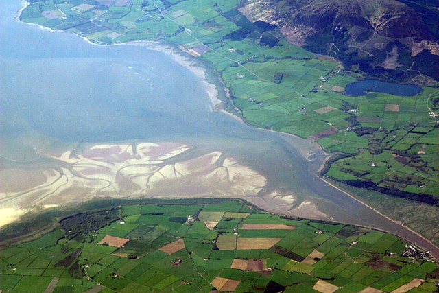
| Priskribo | The estuary of the River Nith, Scotland, at low tide; opening into Solway Firth. This is a view of the Nith estuary from the north-east. The group of buildings at bottom right is the village of Glencaple. At bottom left near the wooded area is Caerlaverock Castle. At top right is Loch Kindar and the hill above is called Criffel. Just beyond the top left of photo is the birthplace of John Paul Jones. |
| Dato | |
| Fonto | https://www.flickr.com/photos/52614599@N00/483602946 |
| Aŭtoro | Doc Searls from Santa Barbara, USA |
Permesiloj:
Ĉi tiu dosiero estas disponebla laŭ la permesilo Krea Komunaĵo Atribuite-Samkondiĉe 2.0 Ĝenerala.
- Vi rajtas:
- kunhavigi – kopii, distribui kaj publikigi la verkon
- aliigi – modifi, adapti, kompletigi, transformi, uzi la tutan verkon aŭ ties partojn, memstare aŭ en aliaj verkoj
- La verko rajtas esti kunhavigata nur:
- atribuite – Vi devas atribui aŭtorecon, liveri ligilon al la permesilo kaj marki ĉu ŝanĝoj estis faritaj. Faru tion en aprobinda maniero, tamen ne sugestante, ke permesinto aprobas vin aŭ vian uzon.
- samkondiĉe – Se vi rekombinas la verkon, transformas ĝin aŭ kreas devenaĵon bazitan sur ĝi, vi rajtas distribui la rezultan verkon nur laŭ la sama aŭ kongrua permesilo kompare kun ĉi tiu.
| This image was originally posted to Flickr by dsearls at https://www.flickr.com/photos/52614599@N00/483602946. It was reviewed on la 5-a de majo 2007 by FlickreviewR and was confirmed to be licensed under the terms of the cc-by-sa-2.0. |
This is a view of the Nith estuary from the north-east. The group of buildings at bottom right is the village of Glencaple. At bottom left near the wooded area is Caerlaverock Castle. At top right is Loch Kindar and the hill above is called Criffel. Just beyond the top left of photo is the birthplace of John Paul Jones.
Dosierhistorio
Alklaku iun daton kaj horon por vidi kiel la dosiero tiam aspektis.
| Dato/Horo | Bildeto | Grandecoj | Uzanto | Komento | |
|---|---|---|---|---|---|
| nun | 07:14, 5 maj. 2007 | | 3 504 × 2 336 (8,68 MB) | Sandstein | {{Information |Description= The estuary of the River Nith, Scotland, at low tide; opening into Solway Firth. On the near shore, Bowness-on-Solway. On the far, Annan, in Dumfries and Galloway. |Source= http://www.flickr.com/photos/52614599@N00/483602946 |D |
Dosiera uzado
La jena paĝo ligas al ĉi tiu dosiero:
Suma uzado de la dosiero
La jenaj aliaj vikioj utiligas ĉi tiun dosieron:
- Uzado en ar.wikipedia.org
- Uzado en arz.wikipedia.org
- Uzado en ast.wikipedia.org
- Uzado en bn.wikipedia.org
- Uzado en br.wikipedia.org
- Uzado en ceb.wikipedia.org
- Uzado en cs.wikipedia.org
- Uzado en cy.wikipedia.org
- Uzado en dag.wikipedia.org
- Uzado en de.wikipedia.org
- Uzado en en.wikipedia.org
- Uzado en en.wikivoyage.org
- Uzado en es.wikipedia.org
- Uzado en eu.wikipedia.org
- Uzado en fa.wikipedia.org
- Uzado en fr.wikipedia.org
- Uzado en fy.wikipedia.org
- Uzado en ga.wikipedia.org
- Uzado en gd.wikipedia.org
- Uzado en gv.wikipedia.org
- Uzado en hak.wikipedia.org
- Uzado en id.wikipedia.org
- Uzado en incubator.wikimedia.org
- Uzado en it.wikipedia.org
- Uzado en it.wikibooks.org
- Uzado en it.wikiversity.org
- Uzado en ja.wikipedia.org
- Uzado en kbd.wikipedia.org
- Uzado en lt.wikipedia.org
- Uzado en nl.wikipedia.org
Vidi plian ĝeneralan uzadon de ĉi tiu dosiero.