Dosiero:Tetiaroa.jpg
Bildo en pli alta difino ((617 × 668 rastrumeroj, grandeco de dosiero: 111 KB, MIME-tipo: image/jpeg))
| Jen dosiero de la Wikimedia-Komunejo. La priskribo en ties priskriba paĝo estas montrata suben.
|
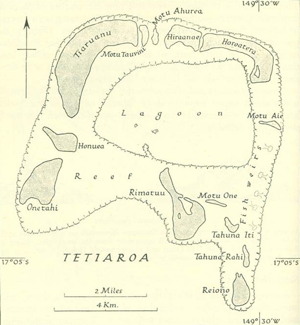
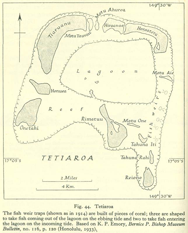
Resumo
http://www.lib.utexas.edu/maps/historical/pacific_islands_1943_1945/tetiaroa.jpg
Public domain, as explained on page http://www.lib.utexas.edu/usage_statement.html?maps=yes: "Most of the maps scanned by the University of Texas Libraries and served from this web site are in the public domain. No permissions are needed to copy them. You may download them and use them as you wish. A few maps are copyrighted, and are clearly marked as such."
The motu of Tahuna Iti and the sandbank of Motu One are interchanged on the map.
Permesiloj:
This file is in the public domain because it has been taken from a collection of public domain maps at the University of Texas Library
|
Dosierhistorio
Alklaku iun daton kaj horon por vidi kiel la dosiero tiam aspektis.
| Dato/Horo | Bildeto | Grandecoj | Uzanto | Komento | |
|---|---|---|---|---|---|
| nun | 08:00, 18 jan. 2014 | | 617 × 668 (111 KB) | Cropbot | upload cropped version, operated by User:Andy king50. Summary: cropped |
| 15:23, 21 okt. 2006 |  | 644 × 797 (92 KB) | Ratzer | http://www.lib.utexas.edu/maps/historical/pacific_islands_1943_1945/tetiaroa.jpg Public domain, as explained on page http://www.lib.utexas.edu/usage_statement.html?maps=yes: "Most of the maps scanned by the University of Texas Libraries and served from t |
Dosiera uzado
La jena paĝo ligas al ĉi tiu dosiero:
Suma uzado de la dosiero
La jenaj aliaj vikioj utiligas ĉi tiun dosieron:
- Uzado en als.wikipedia.org
- Uzado en az.wikipedia.org
- Uzado en ca.wikipedia.org
- Uzado en de.wikipedia.org
- Uzado en en.wikipedia.org
- Uzado en es.wikipedia.org
- Uzado en fr.wikipedia.org
- Uzado en gl.wikipedia.org
- Uzado en hu.wikipedia.org
- Uzado en mk.wikipedia.org
- Uzado en no.wikipedia.org
- Uzado en pl.wikipedia.org
- Uzado en pt.wikipedia.org
- Uzado en ru.wikipedia.org
- Uzado en sv.wikipedia.org
- Uzado en zh.wikipedia.org