Dosiero:150132main image feature 589 alaska.jpg

Bildo en pli alta difino ((5 600 × 4 400 rastrumeroj, grandeco de dosiero: 6,63 MB, MIME-tipo: image/jpeg))
| Jen dosiero de la Wikimedia-Komunejo. La priskribo en ties priskriba paĝo estas montrata suben.
|
Resumo
| Priskribo |
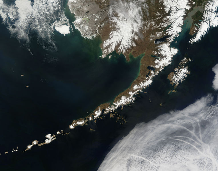
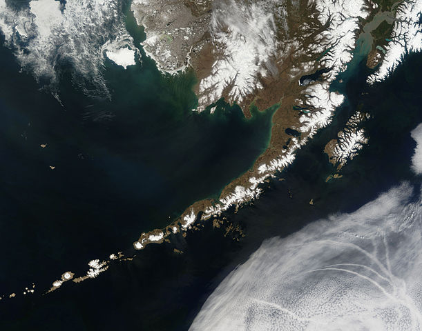
English: Satellite picture of the Aleutian Islands and the Alaska Peninsula, located in the south of the state of Alaska, United States.
Português: Imagem de satélite das Ilhas Aleutas e da Península do Alasca, localizadas no sul do estado do Alasca, Estados Unidos.
Original caption — The Aleutian Islands and the Alaskan peninsula are shown in this image acquired by the MODIS on the Terra satellite, on May 25th, 2006. The Aleutians are a chain of more than 300 small volcanic islands forming an island arc in the Northern Pacific Ocean. They extend about 1,200 miles westward from the Alaskan Peninsula. Nearly all of the islands are part of Alaska, but at the extreme western end of the archipelago are the small, geologically-related, but remote Komandorski Islands, which are considered part of Russia. The Aleutian Islands, with 57 volcanoes among them, are in the northern part of the Pacific Ring of Fire.
|
| Dato | la 25-a de majo 2006 |
| Fonto | NASA (Image galleries) |
| Aŭtoro | National Aeronautics and Space Administration (NASA) |
| Ceteraj versioj |
.jpg)
Assessment
This image was selected as picture of the day on Wikimedia Commons for 2 September 2006. It was captioned as follows: Other languages:
閩南語 / Bân-lâm-gú: Ùi thài-khong koàⁿ Aleutian Kûn-tó kap Alaska Poàⁿ-tó Čeština: Aleutské ostrovy z oběžné dráhy. Cymraeg: Delwedd o'r gofod o'r Ynysoedd Aleutia a'r Gorynys Alaska. Magyar: Az Aleut-szigetek és az Alaszkai-félsziget az űrből nézve Polski: Aleuty i półwysep Alaska widziane z orbity ziemskiej Slovenščina: Aleutski otoki iz vesolja. |
Permesiloj:
| La ĉi-supra dosiero estas publika havaĵo, ĉar ĝi apartenas al NASA. La kopirajta regularo de NASA asertas, ke "ĉiuj dokumentoj de NASA estas publika havaĵo, se ne estas donata kontraŭa deklaro". | ||
 |
Atentu:
|
Dosierhistorio
Alklaku iun daton kaj horon por vidi kiel la dosiero tiam aspektis.
| Dato/Horo | Bildeto | Grandecoj | Uzanto | Komento | |
|---|---|---|---|---|---|
| nun | 19:55, 14 jul. 2006 | | 5 600 × 4 400 (6,63 MB) | Felipe Menegaz | {{Information| |Description= The Aleutian Islands and the Alaskan peninsula are shown in this image acquired by the MODIS on the Terra satellite, on May 25th, 2006. The Aleutians are a chain of more than 300 small volcanic islands forming an island arc in |
Dosiera uzado
La jenaj paĝoj ligas al ĉi tiu dosiero:
Suma uzado de la dosiero
La jenaj aliaj vikioj utiligas ĉi tiun dosieron:
- Uzado en af.wikipedia.org
- Uzado en als.wikipedia.org
- Uzado en bn.wikipedia.org
- Uzado en ca.wikipedia.org
- Uzado en cs.wikipedia.org
- Uzado en de.wikipedia.org
- Uzado en es.wikipedia.org
- Uzado en fr.wikipedia.org
- Uzado en gl.wikipedia.org
- Uzado en hu.wikipedia.org
- Uzado en ia.wikipedia.org
- Uzado en it.wikipedia.org
- Uzado en ja.wikipedia.org
- Uzado en ko.wikipedia.org
- Uzado en oc.wikipedia.org
- Uzado en os.wikipedia.org
- Uzado en pl.wikipedia.org
- Uzado en pl.wiktionary.org
- Uzado en pt.wikipedia.org
- Uzado en ro.wikipedia.org
- Uzado en ru.wikipedia.org
- Uzado en ru.wikinews.org
- Uzado en sah.wikipedia.org
- Uzado en sk.wikipedia.org
- Uzado en sr.wikipedia.org
- Uzado en sv.wikipedia.org
- Uzado en tr.wikipedia.org