Dosiero:1794 Samuel Dunn Wall Map of the World in Hemispheres - Geographicus - World2-dunn-1794.jpg

Bildo en pli alta difino((6 000 × 5 054 rastrumeroj, grandeco de dosiero: 8,92 MB, MIME-tipo: image/jpeg))

Jen dosiero de la Wikimedia-Komunejo. La priskribo en ties priskriba paĝo estas montrata suben.
La Komunejo estas dosieruja retejo de libere licencitaj dosieroj.

Resumo

Titolo
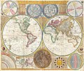
A General Map of the World, or Terraqueous Globe with all the New Discoveries and Marginal Delineations, Containing the Most Interesting Particulars in the Solar, Starry and Mundane System.
Priskribo
العربية: خريطة العالم رسم عالم الرياضيَّات البريطاني صموئيل دان، تعود إلى سنة 1794 م.
Български: Карта на света от британския математик Самюел Дан, 1794 г. Включва и карта на Луната, Слънчевата система и друга информация.
English: An absolutely stunning and monumental double hemisphere wall map of the world by Samuel Dunn dating to 1794. This extraordinary map is so large and so rich in detail that it is exceptionally challenging to do it full justice in either photographic or textual descriptions. Covers the entire world in a double hemisphere projection. The primary map is surrounded on all sides but detailed scientific calculations and descriptions as well as northern and southern hemisphere star charts, a map of the Moon, a Latitude and Longitude Analemma chart, a map of the Solar System, a Mercator projection of the world, an Analemma projection, a seasonal chart, a universal scale chart, and numerous smaller diagrams depicting planets and mathematical systems. All text is in English. We will start our survey of this map in North America, much of which was, even in 1794, largely unknown. This map follows shortly after the explorations of Captain Cook in the Arctic and Pacific Northwest, so the general outline of the continent is known. However, when this map was made, few inland expeditions had extended westward beyond the Mississippi. This map notes two separate speculative courses for the apocryphal River of the West, a northern route extending from Lake Winnipeg and a southern route passing south of Winnepeg through Pike's lake. The River of the West was hopeful dream of French and English explorers who were searching for a water passage through North America to the Pacific. In concept, should such a route be found, it would have become an important trade artery allowing the British and French, who's colonies dominated the eastern parts of North America, to compete with the Spanish for control of the lucrative Asia-Pacific trade. Little did these earlier speculative cartographers realize the bulk of the Rocky Mountains stood between them and their dreams! Slightly south of the Rivers of the West, we find the kingdom of Quivira, which is one of the lands associated with Spanish legends of the Seven Cities of Gold. In this area we can also find Drake's Harbor or Port de la Bodega and Albion. Drake's Harbor is where Sir Francis Drake supposedly landed during his circumnavigation of the globe in 1580. Drake wintered in this harbor and used the abundant resources of the region to repair his ships. He also claimed the lands for England dubbing them New Albion. Although the true location of Drake's port is unknown, most place it much further to the north. By situating it and consequently New Albion further to the south, Dunn is advocating a British rather than Spanish claim to this region. On the Eastern coast of North America we find a fledgling United States extending from Georgia to Maine. Dunn names Boston, New York, Charleston, Long Island, and Philadelphia, as well as the important smaller towns of Jamestown, Williamsburg and Edonton. South America exhibits a typically accurate coastline and limited knowledge of the interior beyond Peru and the populated coastlands. A few islands are noted off the coast, including the Galapagos, which are referred to as the Inchanted Islands. The Amazon is vague with many of its tributaries drawn in speculatively. Dunn and d'Anville have done away with the popular representation of Manoa or El Dorado in Guyana, but a vestigial Lake Parima is evident. Further south, the Laguna de los Xarayes, another apocryphal destination, is drawn at the northernmost terminus of the Paraguay River. The Xaraiés, meaning Masters of the River were an indigenous people occupying what are today parts of Brazil's Matte Grosso and the Pantanal. When Spanish and Portuguese explorers first navigated up the Paraguay River, as always in search of El Dorado, they encountered the vast Pantanal flood plain at the height of its annual inundation. Understandably misinterpreting the flood plain as a gigantic inland sea, they named it after the local inhabitants, the Xaraies.
Español: Mapamundi, elaborado por Samuel Dunn en 1794, que incluye los hemisferios oriental y occidental, asi como un mapa del sistema solar y un mapa lunar, entre otros.
Українська: Настінна карта світу з подвійною півсферою Семюеля Данна, датована 1794 роком.
Dato (dated)
Fonto

Kitchin, Thomas, Kitchin's General Atlas, describing the Whole Universe: being a complete collection of the most approved maps extant; corrected with the greatest care, and augmented from the last edition of D'Anville and Robert with many improvements by other eminent geographers, engraved on Sixty-Two plates, comprising Thirty Seven maps., Laurie & Whittle, London, 1797.

Kreinto
Georeferencing Georeference the map in Wikimaps Warper If inappropriate please set warp_status = skip to hide.
 Archival data
Akirnumero
Geographicus link: World2-dunn-1794
Dimensioj alto: 42 coloj (106,6 cm); larĝo: 49 coloj (124,4 cm)
dimensions QS:P2048,42U218593
dimensions QS:P2049,49U218593


Assessment

Featured bildo

Vikimedia KomunejoVikipedio

Ĉi tiu dosiero estas elstara bildo en Vikimedia Komunejo (Elstaraj bildoj) kaj estas konsiderata unu el la plej elstaraj bildoj.

 Ĉi tiu dosiero estas elstara bildo en projekto Vikipedio en lingvo araba (صور مختارة) kaj estas konsiderata unu el la plej elstaraj bildoj.
 Ĉi tiu dosiero estas elstara bildo en projekto Vikipedio en lingvo persa (نگاره‌های برگزیده) kaj estas konsiderata unu el la plej elstaraj bildoj.

Se vi havas dosieron en komparebla kvalito, kiun vi povas publikigi sub konvena libera licenco, tiam alŝutu la dosieron, donu al ĝi taŭgan prilicencan indikon kaj nomumu ĝin!

Permesiloj:

Public domain

Tiu ĉi verko estas publika havaĵo en tiuj landoj, kies kopirajtado validas por longo de vivo plus 100 jaroj aŭ malpli.


This work is in the public domain in the United States because it was published (or registered with the U.S. Copyright Office) before January 1, 1929.

Titoloj

Donu unulinian priskribon de la enhavo de ĉi tiu dosiero
World map by Samuel Dunn from 1794, artist Thomas Kitchin

Eroj prezentitaj en ĉi tiu dosiero

montras

image/jpeg

39ae435a6440134490cb6aa24d2c64b377bd242b

9 350 888 bajto

5 054 rastrumero

6 000 rastrumero

Dosierhistorio

Alklaku iun daton kaj horon por vidi kiel la dosiero tiam aspektis.

Dato/HoroBildetoGrandecojUzantoKomento
nun20:01, 1 jun. 2012Bildeto por versio ekde 20:01, 1 jun. 20126 000 × 5 054 (8,92 MB)Brandmeister~commonswikiReverted to version as of 04:17, 23 March 2011
16:15, 19 maj. 2012Bildeto por versio ekde 16:15, 19 maj. 20126 000 × 5 054 (27,38 MB)Brandmeister~commonswikicontrast
04:17, 23 mar. 2011Bildeto por versio ekde 04:17, 23 mar. 20116 000 × 5 054 (8,92 MB)BotMultichillT{{subst:User:Multichill/Geographicus |link=http://www.geographicus.com/P/AntiqueMap/World2-dunn-1794 |product_name=1794 Samuel Dunn Wall Map of the World in Hemispheres |map_title=A General Map of the World, or Terraqueouis Globe with all the New Discover

La jena paĝo ligas al ĉi tiu dosiero:

Suma uzado de la dosiero

La jenaj aliaj vikioj utiligas ĉi tiun dosieron:

Vidi plian ĝeneralan uzadon de ĉi tiu dosiero.