Dosiero:British Guiana - 1908 - WDL.png

Grandeco de ĉi antaŭvido: 376 × 600 rastrumeroj. Aliaj distingivoj: 150 × 240 rastrumeroj | 301 × 480 rastrumeroj | 481 × 768 rastrumeroj | 642 × 1 024 rastrumeroj | 1 283 × 2 048 rastrumeroj | 4 080 × 6 510 rastrumeroj.
Bildo en pli alta difino ((4 080 × 6 510 rastrumeroj, grandeco de dosiero: 32,48 MB, MIME-tipo: image/png))
| Jen dosiero de la Wikimedia-Komunejo. La priskribo en ties priskriba paĝo estas montrata suben.
|
Resumo
| Priskribo |
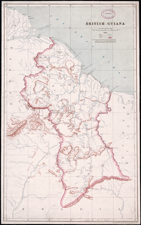
English: British Guiana, 1908
Creator: Great Britain. Ordnance Survey Surveyor: Anderson, Charles Wilgress "This map, prepared and printed in 1908 at the office of the Ordnance Survey, Southampton, United Kingdom, provides a relatively detailed view of the geography of British Guiana (present-day Guyana), one of only two British colonies on the mainland of South and Central America (the other being British Honduras). A note indicates that the portion of the map north of 5° North latitude is from a map prepared by the government surveyor of British Guiana, while the remainder of the map “has been compiled from various sources and is less reliable.” Much of the territory in the south of the country was as yet unexplored. Bordered to the west by Venezuela, to the south by Brazil, and to the east by Dutch Guiana (present-day Suriname), British Guiana was the subject of a longstanding border dispute with Venezuela, in which the United States became involved and that was settled by arbitration in 1899. The map reflects the settlement, which awarded Britain most of the disputed territory but gave Venezuela undisputed control over the Orinoco River. The map shows international borders, cities and towns, railroads, posts and forts, and physical features such as rivers, cataracts, and hills and mountains." |
| Dato | |
| Fonto | http://www.wdl.org/en/item/11328/ |
| Aŭtoro | Great Britain. Ordnance Survey |
Permesiloj:
This media file is in the public domain in the United States. This applies to U.S. works where the copyright has expired, often because its first publication occurred prior to January 1, 1929, and if not then due to lack of notice or renewal. See this page for further explanation.
|
 | |
 |
This image might not be in the public domain outside of the United States; this especially applies in the countries and areas that do not apply the rule of the shorter term for US works, such as Canada, Mainland China (not Hong Kong or Macao), Germany, Mexico, and Switzerland. The creator and year of publication are essential information and must be provided. See Wikipedia:Public domain and Wikipedia:Copyrights for more details.
|
Dosierhistorio
Alklaku iun daton kaj horon por vidi kiel la dosiero tiam aspektis.
| Dato/Horo | Bildeto | Grandecoj | Uzanto | Komento | |
|---|---|---|---|---|---|
| nun | 08:58, 18 jan. 2020 | | 4 080 × 6 510 (32,48 MB) | ZiaLater | More detailed version |
| 20:39, 23 okt. 2013 |  | 1 024 × 1 631 (2,71 MB) | SarahStierch | User created page with UploadWizard |
Dosiera uzado
La jena paĝo ligas al ĉi tiu dosiero:
Suma uzado de la dosiero
La jenaj aliaj vikioj utiligas ĉi tiun dosieron:
- Uzado en en.wikipedia.org
- Uzado en es.wikipedia.org
- Uzado en fa.wikipedia.org
- Uzado en fr.wikipedia.org
- Uzado en he.wikipedia.org
- Uzado en hr.wikipedia.org
- Uzado en is.wikipedia.org
- Uzado en it.wikipedia.org
- Uzado en ms.wikipedia.org
- Uzado en mt.wikipedia.org
- Uzado en pt.wikipedia.org
- Uzado en ru.wikipedia.org
- Uzado en zh.wikipedia.org