Dosiero:CircumnavigationByTrades.png
CircumnavigationByTrades.png ((800 × 500 rastrumeroj, grandeco de dosiero: 287 KB, MIME-tipo: image/png))
| Jen dosiero de la Wikimedia-Komunejo. La priskribo en ties priskriba paĝo estas montrata suben.
|
Resumo
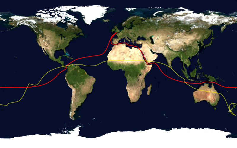
This image shows the route, in red, of a typical sailing circumnavigation of the world via the Panama Canal and Suez Canal, making use of the trade winds. Shown in yellow is the antipodean point of each point on the route; it can be seen that a boat following this route will pass through several points antipodean to each other, thus satisfying one definition of a circumnavigation.
This image was constructed from a public domain Visible Earth product of the Earth Observatory office of the United States government space agency NASA. It is based on a cylindrical equi-distant projection.
Permesiloj:
| This image is in the public domain because it is a screenshot from NASA’s globe software World Wind using a public domain layer, such as Blue Marble, MODIS, Landsat, SRTM, USGS or GLOBE.
|
 |
Dosierhistorio
Alklaku iun daton kaj horon por vidi kiel la dosiero tiam aspektis.
| Dato/Horo | Bildeto | Grandecoj | Uzanto | Komento | |
|---|---|---|---|---|---|
| nun | 16:03, 23 jan. 2006 | | 800 × 500 (287 KB) | Johantheghost | This image shows the route, in red, of a typical sailing circumnavigation of the world via the Panama Canal and Suez Canal, making use of the [[Wikipe |
Dosiera uzado
La jena paĝo ligas al ĉi tiu dosiero:
Suma uzado de la dosiero
La jenaj aliaj vikioj utiligas ĉi tiun dosieron:
- Uzado en ast.wikipedia.org
- Uzado en da.wikipedia.org
- Uzado en en.wikipedia.org
- Uzado en es.wikipedia.org
- Uzado en fi.wikipedia.org
- Uzado en he.wikipedia.org
- Uzado en ja.wikipedia.org
- Uzado en ko.wikipedia.org
- Uzado en la.wikipedia.org
- Uzado en nl.wikipedia.org
- Uzado en nn.wikipedia.org
- Uzado en no.wikipedia.org
- Uzado en pl.wikipedia.org
- Uzado en pt.wikipedia.org
- Uzado en ru.wikipedia.org
- Uzado en simple.wikipedia.org