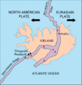
Dosiero:Iceland Mid-Atlantic Ridge Fig16.gif
Iceland_Mid-Atlantic_Ridge_Fig16.gif ((376 × 390 rastrumeroj, grandeco de dosiero: 9 KB, MIME-tipo: image/gif))
Dosierhistorio
Alklaku iun daton kaj horon por vidi kiel la dosiero tiam aspektis.
| Dato/Horo | Bildeto | Grandecoj | Uzanto | Komento | |
|---|---|---|---|---|---|
| nun | 23:02, 9 mar. 2005 |  | 376 × 390 (9 KB) | Svart~commonswiki | Map showing the Mid-Atlantic Ridge splitting Iceland and separating the North American and Eurasian Plates. The map also shows Reykjavik, the capital of Iceland, the Thingvellir area, and the locations of some of Iceland's active volcanoes (red triangles) |
Dosiera uzado
La jena paĝo ligas al ĉi tiu dosiero:
Suma uzado de la dosiero
La jenaj aliaj vikioj utiligas ĉi tiun dosieron:
- Uzado en ar.wikipedia.org
- Uzado en ast.wikipedia.org
- Uzado en azb.wikipedia.org
- Uzado en bg.wikipedia.org
- Uzado en bn.wikipedia.org
- Uzado en bn.wikivoyage.org
- Uzado en cs.wikipedia.org
- Uzado en de.wikipedia.org
- Uzado en de.wikivoyage.org
- Uzado en dz.wikipedia.org
- Uzado en en.wikipedia.org
- Uzado en es.wikipedia.org
- Uzado en fa.wikipedia.org
- Uzado en fiu-vro.wikipedia.org
- Uzado en fi.wikipedia.org
- Uzado en hr.wikipedia.org
- Uzado en hu.wikipedia.org
- Uzado en is.wikipedia.org
- Uzado en is.wikibooks.org
- Uzado en it.wikipedia.org
- Uzado en ja.wikipedia.org
- Uzado en ms.wikipedia.org
- Uzado en nds.wikipedia.org
- Uzado en nn.wikipedia.org
- Uzado en no.wikipedia.org
- Uzado en pl.wikipedia.org
- Uzado en pt.wikipedia.org
- Uzado en rm.wikipedia.org
- Uzado en ro.wikipedia.org
Vidi plian ĝeneralan uzadon de ĉi tiu dosiero.


