Bildo en pli alta difino(SVG-dosiero, 1 033 × 991 rastrumeroj, grandeco de dosiero: 805 KB)

Jen dosiero de la Wikimedia-Komunejo. La priskribo en ties priskriba paĝo estas montrata suben.
La Komunejo estas dosieruja retejo de libere licencitaj dosieroj.

Resumo

Selected maps are included in the  Wikimedia Atlas of Libya.

See also :

Priskribo
Deutsch:
 
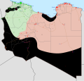
Unter Kontrolle des Abgeordnetenrats in Tobruk und der Allianz der Nationalen Kräfte
 
Kontrolliert durch den Islamischen Staat
 
Kontrolliert durch Ansar al-Scharia
 
Kontrolliert durch lokale Kräfte
 
Kontrolliert durch Kräfte der Tuareg
English:
 
Under the control of the House of Representatives in Tobruk and the Libyan National Army
 
Under the control of the Government of National Accord and the Libya Shield Force
 
Under the control of the National Salvation Government
 
Controlled by the Mujahedeen Councils of Derna, Benghazi and Adjabiya
 
Controlled by local forces
 
Controlled by Tuareg forces
Español:
 
Controlado por el Gobierno de Acuerdo Nacional y la Fuerza del Escudo de Libia.
 
Controlado por el Congreso General Nacional.
 
Controlado por el Estado Islámico.
 
Controlado por los Consejos de la Shura de los Muyahidines de Derna, Bengasi y Ajdabiya.
 
Controlado por fuerzas locales.
 
Controlado por las milicias de los Tuareg.
Italiano:
 
Sotto il controllo del Governo di Tobruk e Alleati
 
Sotto il controllo del Nuovo Congresso Nazionale Generale e Alleati
 
Controllato dallo Stato Islamico
 
Controllato dallo Ansar al-Sharia (Libia)
 
Controllato da gruppi armati non affiliati
 
Controllato dai Tuareg
Magyar:
 
Nemzetközi szövetségi erők kezén lévő terület
 
Nemzeti Egységkormány irányítása alatt álló terület
 
Az Új Egységkormány irányítása alatt álló terület
 
az Iszlám Állam kezén lévő terület
 
Ansar al-Scharia kezén lévő terület
 
Helyi erők irányítása alatt álló terület
 
Tuaregek irányítása alatt álló terület
Türkçe:
 
Tobruk'taki Temsilciler Meclisi ve Libya Ulusal Ordusu tarafından kontrol edilen yerler
 
Ulusal Mutabakat Hükûmeti ve Libya Silahlı Kuvvetleri tarafından kontrol edilen yerler
 
Ulusal Kurtuluş Hükûmeti tarafından kontrol edilen yerler
 
Irak ve Şam İslam Devleti tarafından kontrol edilen yerler
 
Derne, Bingazi ve Ecdebiye mücahit şuraları tarafından kontrol edilen yerler
 
Yerel güçler tarafından kontrol edilen yerler
 
Tuareg kuvvetleri tarafından kontrol edilen yerler
Русский:
 
Под контролем Советов моджахедов шуры в Дерне, Бенгази и Адждабии
 
Под контролем местных милиций
 
Под контролем туарегской милиции
العربية :
 
تحت سيطرة داعش
 
تحت سيطرة مجموعات قبلية محلية غير منتمية
 
تحت سيطرة قوات الطوارق
فارسی :
 
در دست مجلس ملی نو و ائتلاف (اسلامگرایان)
 
در دست داعش
 
در دست نیروهای قبیله‌ای و محلی غیروابسته
 
در دست نیروهای طوارق
Dato February 2016 (vector map)
Fonto Derived from Template:Libyan Civil War detailed map
Aŭtoro Ali Zifan (vectorized map)
Ceteraj versioj
Ongoing armed conflicts ( Countries Maps )
National or regional Maps of ongoing insurgencies, armed conflicts, disputes of territories, military conflicts, and also current civil or international wars :

See also:
Category:Conflicts in 2024 (with list of countries in ongoing armed conflicts)
Template:City maps of ongoing civil wars (Local maps)

Ongoing armed conflicts ( Local & City Maps )

Permesiloj:

Mi, la posedanto de la aŭtorrajto por ĉi tiu verko, ĉi-maniere publikigas tiun laŭ la jena permesilo:
w:eo:Creative Commons
atribuite samkondiĉe
Ĉi tiu dosiero disponeblas laŭ la permesilo Krea Komunaĵo Atribuite-Samkondiĉe 4.0 Tutmonda.
Vi rajtas:
  • kunhavigi – kopii, distribui kaj publikigi la verkon
  • aliigi – modifi, adapti, kompletigi, transformi, uzi la tutan verkon aŭ ties partojn, memstare aŭ en aliaj verkoj
La verko rajtas esti kunhavigata nur:
  • atribuite – Vi devas atribui aŭtorecon, liveri ligilon al la permesilo kaj marki ĉu ŝanĝoj estis faritaj. Faru tion en aprobinda maniero, tamen ne sugestante, ke permesinto aprobas vin aŭ vian uzon.
  • samkondiĉe – Se vi rekombinas la verkon, transformas ĝin aŭ kreas devenaĵon bazitan sur ĝi, vi rajtas distribui la rezultan verkon nur laŭ la sama aŭ kongrua permesilo kompare kun ĉi tiu.

Titoloj

Donu unulinian priskribon de la enhavo de ĉi tiu dosiero

Eroj prezentitaj en ĉi tiu dosiero

montras

image/svg+xml

Dosierhistorio

Alklaku iun daton kaj horon por vidi kiel la dosiero tiam aspektis.

(plej lasta | plej frua) Montri (pli novajn 10 | ) (10 | 20 | 50 | 100 | 250 | 500)
Dato/HoroBildetoGrandecojUzantoKomento
nun14:09, 15 jun. 2020Bildeto por versio ekde 14:09, 15 jun. 20201 033 × 991 (805 KB)BeshogurReverted to version as of 11:12, 10 June 2020 (UTC) Why?
13:09, 15 jun. 2020Bildeto por versio ekde 13:09, 15 jun. 20201 033 × 991 (693 KB)EastMedmapsReverted to version as of 12:39, 9 April 2019 (UTC)
11:12, 10 jun. 2020Bildeto por versio ekde 11:12, 10 jun. 20201 033 × 991 (805 KB)RobertPaulshonTuareg militias have announce support for GNA https://www.middleeastmonitor.com/20200610-libyas-tuareg-brigades-recognise-gna/
13:22, 9 jun. 2020Bildeto por versio ekde 13:22, 9 jun. 20201 033 × 991 (821 KB)Rr016Update: LNA withdrew from western Libya; also added Zintan and Petroleum Facilities Guard militias control in purple and sky blue patterns. Minor corrections were also made.
07:02, 8 jun. 2020Bildeto por versio ekde 07:02, 8 jun. 20201 033 × 991 (804 KB)RobertPaulshonGNA has captured Shwayrif and surrounding desert
23:10, 7 jun. 2020Bildeto por versio ekde 23:10, 7 jun. 20201 033 × 991 (816 KB)Rr016Update: GNA reversed all LNA gains during Operation Flood of Dignity, clashes ongoing at Sirte, added Amazigh presence to map. Bani Walid is neutral under the control of local tribe; GNA is allowed to use the roads and airport.
06:21, 7 jun. 2020Bildeto por versio ekde 06:21, 7 jun. 20201 033 × 991 (778 KB)RobertPaulshonBani Walid should be green since GNA captured it on Friday
16:15, 6 jun. 2020Bildeto por versio ekde 16:15, 6 jun. 20201 033 × 991 (795 KB)Rr016Frontline corrections and update: GNA forces are clashing with LNA in Sirte
19:18, 5 jun. 2020Bildeto por versio ekde 19:18, 5 jun. 20201 033 × 991 (703 KB)RobertPaulshonUpdate, GNA captures Bani Walid
08:31, 5 jun. 2020Bildeto por versio ekde 08:31, 5 jun. 20201 033 × 991 (703 KB)RobertPaulshonUpdate, GNA captures Tarhuna, Musayyah, Davun and Al Urban.
(plej lasta | plej frua) Montri (pli novajn 10 | ) (10 | 20 | 50 | 100 | 250 | 500)

La jena paĝo ligas al ĉi tiu dosiero:

Suma uzado de la dosiero

La jenaj aliaj vikioj utiligas ĉi tiun dosieron:

Vidi plian ĝeneralan uzadon de ĉi tiu dosiero.

Metadatumoj