Dosiero:Mapa dos caminhos de ferro em Portugal 1895 - Sul e Sueste.jpg

Bildo en pli alta difino((1 498 × 1 306 rastrumeroj, grandeco de dosiero: 1,35 MB, MIME-tipo: image/jpeg))

Jen dosiero de la Wikimedia-Komunejo. La priskribo en ties priskriba paĝo estas montrata suben.
La Komunejo estas dosieruja retejo de libere licencitaj dosieroj.

Resumo

Priskribo
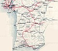
English: Map of the Caminhos de Ferro do Sul e Sueste (South and Southeastern Railway), in Portugal, in 1895. The South and Southeastern railway was a state network that connected the town of Barreiro to the regions of Alentejo and Algarve. At Barreiro, there is a ferry terminal with services to the capital, Lisbon, which was at the other side of the Tagus River. In 1895, the main line between Barreiro and Faro was already completed, with branch lines to Pias, Setúbal and Estremoz.
Português: Mapa da rede dos Caminhos de Ferro do Sul e Sueste, em Portugal, em 1895. A rede ferroviária do Sul e Sueste, controlada pelo estado português, unia o Barreiro às regiões do Alentejo e Algarve. No Barreiro, existem serviços de cacilheiros para a capital de Portugal, Lisboa, que está situada no outro lado do rio. Em 1895, a linha principal já estava construída desde o Barreiro até Faro, mais os ramais até Pias, Setúbal e Estremoz.
Dato
Fonto Tiu ĉi dosiero estas derivita de: Mapa dos caminhos de ferro em Portugal 1895.jpg
Aŭtoro


Ĉi tio estas modifita bildo, kio signifas, ke ĝi ekestis per cifereca aliigo de la origina versio. Modifoj: Isolated the former South and Southeast railway network.. La originaĵo videblas ĉi tie: Mapa dos caminhos de ferro em Portugal 1895.jpg. La modifojn faris Ajpvalente.

Permesiloj:

Public domain

Tiu ĉi verko estas publika havaĵo en tiuj landoj, kies kopirajtado validas por longo de vivo plus 70 jaroj aŭ malpli.


This work is in the public domain in the United States because it was published (or registered with the U.S. Copyright Office) before January 1, 1929.

Originala alŝutada protokolo

This image is a derivative work of the following images:

Uploaded with derivativeFX

Titoloj

Donu unulinian priskribon de la enhavo de ĉi tiu dosiero

Eroj prezentitaj en ĉi tiu dosiero

montras

image/jpeg

e391ef7bae23f9af181ebd75837a39063fcc9aaf

1 418 541 bajto

1 306 rastrumero

1 498 rastrumero

Dosierhistorio

Alklaku iun daton kaj horon por vidi kiel la dosiero tiam aspektis.

Dato/HoroBildetoGrandecojUzantoKomento
nun09:02, 23 okt. 2018Bildeto por versio ekde 09:02, 23 okt. 20181 498 × 1 306 (1,35 MB)Ajpvalente== {{int:filedesc}} == {{Information |Description={{en|1=Map of the Caminhos de Ferro do Sul e Sueste (South and Southeastern Railway), in Portugal, in 1895. The South and Southeastern railway was a state network that connected the town of Barreiro to the regions of Alentejo and Algarve. At Barreiro, there is a ferry terminal with services to the capital, Lisbon, which was at the other side of the Tagus River. In 1895, the main line between Barreiro and Faro was already completed, with branch...

La jena paĝo ligas al ĉi tiu dosiero:

Suma uzado de la dosiero