Dosiero:Rb-map.png
Rb-map.png ((328 × 352 rastrumeroj, grandeco de dosiero: 13 KB, MIME-tipo: image/png))
| Jen dosiero de la Wikimedia-Komunejo. La priskribo en ties priskriba paĝo estas montrata suben.
|
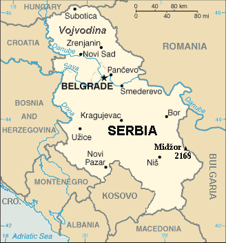
| Priskribo | Map of the Republic of Serbia (FIPS 10 country code standard: RB) | |||
| Dato | ||||
| Fonto | The World Factbook (published by CIA in 2008). | |||
| Aŭtoro | Central Intelligence Agency of the Government of the United States of America | |||
| Permeso (Reuzo de la dosiero) |
|
|||
| Ceteraj versioj | Recommend that Image:Sr-map.png should be deleted and Image:Serbia-CIA WFB Map.png should be spared to show how the map looked before 2008. |
Resumo
Map of Serbia from The World Factbook archive copy at the Wayback Machine (published by CIA in 2008).
This map is updated with current events; independence of Kosovo and certain faults like BUL. is replaced with BULGARIA. The name of the country is in bold font, like the name of the Autonomous Province of Vojvodina (Northern Serbian province). Also the highest mountain in Serbia (Central Serbia region) is marked at the border with Bulgaria with the name of that peak - Midžor - and added the height in meters.
The name of the file
The National Geospatial-Intelligence Agency maintains the FIPS 10 country code standard that US Government use.
On 2006-07-11 the following changes have been made:
DELETE the following geopolitical entities and codes:
- YI SERBIA AND MONTENEGRO
- YI01 Crna Gora (Montenegro)
- YI02 Srbija (Serbia)
ADD the following geopolitical entity and code:
- MJ MONTENEGRO
ADD the following geopolitical entity and code:
- RB SERBIA
The notice was issued by:
Randall E. Flynn
Geographer
National Geospatial-Intelligence Agency
GEOnet Names Server at this web-site.
Recommend that Image:Sr-map.png should be deleted and Image:Serbia-CIA WFB Map.png should be spared to show how the map looked before 2008.
Permesiloj:
Tiu-ĉi dosiero estas publika havaĵo, ĉar ĝi konsistas el bilda materialo el la CIA World Factbook, kiu origine publikiĝis fare de la Centra Inform-Agentejo de Usono.
|
 |
For enhancements
| Mi, la posedanto de la aŭtorrajto por ĉi tiu verko, liberigas ĝin tutmonde kiel publikan havaĵon. En iuj landoj tio povas esti laŭleĝe neebla; en tiu okazo: Mi rajtigas ĉiun ajn uzi ĉi tiun verkon por ajna celo, sen iuj ajn kondiĉoj, krom se tiuj kondiĉoj estas postulataj per leĝo. |
Dosierhistorio
Alklaku iun daton kaj horon por vidi kiel la dosiero tiam aspektis.
| Dato/Horo | Bildeto | Grandecoj | Uzanto | Komento | |
|---|---|---|---|---|---|
| nun | 21:22, 15 jan. 2014 | | 328 × 352 (13 KB) | Denniss | Reverted to version as of 19:30, 14 February 2008 |
| 21:13, 15 jan. 2014 |  | 328 × 352 (36 KB) | Ivan VA | updating borders | |
| 21:12, 15 jan. 2014 |  | 328 × 352 (36 KB) | Ivan VA | vandalizm | |
| 22:29, 2 jan. 2014 |  | 328 × 352 (13 KB) | No More Cats | oops, I got the wrong version | |
| 16:11, 2 jan. 2014 |  | 328 × 352 (13 KB) | No More Cats | Reverted to version as of 12:25, 28 February 2011 - original CIA map | |
| 13:53, 8 aŭg. 2013 |  | 328 × 352 (36 KB) | Pokrajac | Reverted to version as of 21:00, 11 February 2011 | |
| 12:25, 28 feb. 2011 |  | 328 × 352 (13 KB) | IJA | Reverted to version as of 19:30, 14 February 2008 | |
| 21:00, 11 feb. 2011 |  | 328 × 352 (36 KB) | Pokrajac | {{Information |Description=Map of the Republic of Serbia (FIPS 10 country code standard: RB) |Source=[https://www.cia.gov/library/publications/the-world-factbook/geos/rb.html The World Factbook] (published by CIA in 2008). |Date=2008-02-28 |Author=Central | |
| 19:30, 14 feb. 2008 |  | 328 × 352 (13 KB) | Imbris~commonswiki | {{Information |Description=Map of the Republic of Serbia (FIPS 10 country code standard: RB) |Source=[https://www.cia.gov/library/publications/the-world-factbook/geos/rb.html The World Factbook] (published by CIA in 2008). |Date=2008-06-15 |Author=Central |
Dosiera uzado
La jena paĝo ligas al ĉi tiu dosiero:
Suma uzado de la dosiero
La jenaj aliaj vikioj utiligas ĉi tiun dosieron:
- Uzado en de.wikipedia.org
- Uzado en he.wikipedia.org
- Uzado en nl.wiktionary.org
- Uzado en to.wikipedia.org