Dosiero:Rheiderland de.png

Grandeco de ĉi antaŭvido: 710 × 600 rastrumeroj. Aliaj distingivoj: 284 × 240 rastrumeroj | 568 × 480 rastrumeroj | 1 000 × 845 rastrumeroj.
Bildo en pli alta difino ((1 000 × 845 rastrumeroj, grandeco de dosiero: 366 KB, MIME-tipo: image/png))
| Jen dosiero de la Wikimedia-Komunejo. La priskribo en ties priskriba paĝo estas montrata suben.
|
| Priskribo |
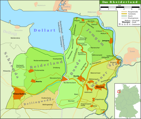
Deutsch: Karte der Region Rheiderland/Reiderland im Nordwesten Deutschlands/Nordosten der Niederlande
English: Map of the region Rheiderland/Reiderland in the north west of Germany/north east of the Netherlands
Plattdüütsch: Kaart van de Region Rheiderland in Noordwest van Düütschland/Noordoost van de Nedderlannen (Schriften hoochdüütsch) |
||
| Dato | |||
| Fonto | own work (based on several atlases and [1]) | ||
| Aŭtoro | Onno Gabriel | ||
| Permeso (Reuzo de la dosiero) |
Mi, la posedanto de la aŭtorrajto por ĉi tiu verko, ĉi-maniere publikigas ĝin laŭ la jenaj permesiloj:
Ĉi tiu dosiero estas disponebla laŭ la permesilo Krea Komunaĵo Atribuite 3.0 Neadaptita.
Vi povas elekti la permesilon preferatan. |
||
| Ceteraj versioj | The map is not correct, because it considers the villages Scheemda, MIdwolda en Oostwold to the old district Reiderland, but omits Heiligerlee and Westerlee. |

Dosierhistorio
Alklaku iun daton kaj horon por vidi kiel la dosiero tiam aspektis.
| Dato/Horo | Bildeto | Grandecoj | Uzanto | Komento | |
|---|---|---|---|---|---|
| nun | 13:06, 26 aŭg. 2007 | | 1 000 × 845 (366 KB) | Onno~commonswiki | {{Information |Description = {{de|Karte der Region Rheiderland/Reiderland im Nordwesten Deutschlands/Nordosten der Niederlande}} {{en|Map of the region Rheiderland/Reiderland in the north west of Germany/north east of the Netherlands}} {{nds|Kaart van de |
| 15:27, 25 aŭg. 2007 |  | 1 000 × 845 (345 KB) | Onno~commonswiki | {{Information |Description = {{de|Map of the region Rheiderland/Reiderland in the north west of Germany/north east of the Netherlands}} {{en|Karte der Region Rheiderland/Reiderland im Nordwesten Deutschlands/Nordosten der Niederlande}} |Source = own work |
Dosiera uzado
La jena paĝo ligas al ĉi tiu dosiero:
Suma uzado de la dosiero
La jenaj aliaj vikioj utiligas ĉi tiun dosieron:
- Uzado en azb.wikipedia.org
- Uzado en da.wikipedia.org
- Uzado en de.wikipedia.org
- Pogum
- Bunde
- Boen
- Rheiderland
- Jemgum
- Midlum (Rheiderland)
- Critzum
- Ditzum
- Holtgaste
- Benutzer:Onno
- Bunderhee
- Stapelmoor
- Kirchborgum
- Nendorp
- Wymeer
- Ditzumerverlaat
- Marienchor
- Weener
- Wikipedia:WikiProjekt Ostfriesland/Kartenzimmer
- Möhlenwarf
- Hatzum
- Landschaftspolder
- Beschotenweg
- Diele (Weener)
- St. Georgiwold
- Weenermoor
- Dollart (Bunde)
- Dielerheide
- Halte
- Holthusen (Weener)
- Holthuserheide
- Stapelmoorerheide
- Tichelwarf
- Heinitzpolder
- Kanalpolder
- Böhmerwold
- Oldendorp
- Wikipedia:Kartenwerkstatt/Archiv/2011-10
- Bunderhammrich
- Ditzumerhammrich
- Vellage
- Benutzer:Aeroid/List DE NI Dorf
- Uzado en fy.wikipedia.org
Vidi plian ĝeneralan uzadon de ĉi tiu dosiero.