Dosiero:SDBayAreaNASA.jpg

Grandeco de ĉi antaŭvido: 600 × 600 rastrumeroj. Aliaj distingivoj: 240 × 240 rastrumeroj | 480 × 480 rastrumeroj | 768 × 768 rastrumeroj | 1 024 × 1 024 rastrumeroj | 2 048 × 2 048 rastrumeroj | 4 055 × 4 055 rastrumeroj.
Bildo en pli alta difino ((4 055 × 4 055 rastrumeroj, grandeco de dosiero: 13,45 MB, MIME-tipo: image/jpeg))
| Jen dosiero de la Wikimedia-Komunejo. La priskribo en ties priskriba paĝo estas montrata suben.
|
Resumo
| Priskribo |
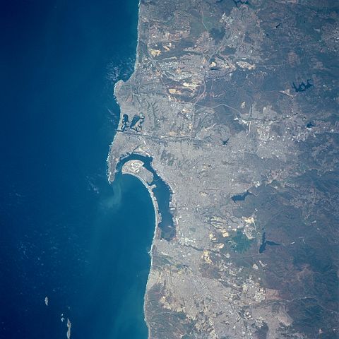
English: Three major features dominate this image of the southwest coast of California: the deep blue (dark) waters of the Pacific Ocean; the highly reflective, man-made urban and suburban environment along the coast; and the rugged, natural terrain of low mountain foothills of the Peninsular Ranges east of the urban development. The greater metropolitan area of San Diego (CA) and Tijuana (Mexico) with a combined population of approximately four million people can be identified as the lighter colored, highly reflective area on the image. Several types of infrastructure associated with the developed urban area are visible on this small-scale image. Reservoirs, including the lower Otay, Sweetwater, and St. Vicente Reservoirs, are the irregularly shaped, dark blue areas. The light-colored linear runways of Miramar Naval Air Station lie north of the densely populated area of San Diego. Interstate Highways 5 and 15 (light colored, linear features) radiate northward away from San Diego. The small square-shaped features along the edges of the bay are the many piers that jut into San Diego Bay. Mission Bay Harbor and Marina (dark area) is found along the coast north of the entrance to San Diego Bay. |
| Dato | la 20-a de aprilo 1998, 19:45:12 UTC |
| Fonto | Image courtesy of Earth Sciences and Image Analysis Laboratory, NASA Johnson Space Center: NASA photo STS090-758-17 (mission STS090, roll 758, frame 17); high-resolution version from ftp://eol.jsc.nasa.gov/EFS_highres_STS090_STS090-758-17.JPG |
| Aŭtoro | NASA |
| Pozicio de la fotilo | | Tiu cxi bildo kaj pliaj sur OpenStreetMap |
|---|
Permesiloj:
| La ĉi-supra dosiero estas publika havaĵo, ĉar ĝi apartenas al NASA. La kopirajta regularo de NASA asertas, ke "ĉiuj dokumentoj de NASA estas publika havaĵo, se ne estas donata kontraŭa deklaro". | ||
 |
Atentu:
|
| Annotations | This image is annotated: View the annotations at Commons |
Dosierhistorio
Alklaku iun daton kaj horon por vidi kiel la dosiero tiam aspektis.
| Dato/Horo | Bildeto | Grandecoj | Uzanto | Komento | |
|---|---|---|---|---|---|
| nun | 22:24, 30 jun. 2012 | | 4 055 × 4 055 (13,45 MB) | Closeapple | high-resolution version from ftp://eol.jsc.nasa.gov/EFS_highres_STS090_STS090-758-17.JPG |
| 00:16, 16 feb. 2011 |  | 639 × 639 (344 KB) | 08OceanBeach SD | brightened | |
| 00:10, 24 jan. 2011 |  | 639 × 639 (322 KB) | 08OceanBeach SD | {{Information |Description ={{en|1=Satellite map of the San Diego Urban and Bay Area from the National Aeronautics and Space Administration. Three major features dominate this image of the southwest coast of California: |
Dosiera uzado
La jena paĝo ligas al ĉi tiu dosiero:
Suma uzado de la dosiero
La jenaj aliaj vikioj utiligas ĉi tiun dosieron:
- Uzado en ceb.wikipedia.org
- Uzado en de.wikipedia.org
- Uzado en en.wikipedia.org
- Uzado en es.wikipedia.org
- Uzado en fr.wikipedia.org
- Uzado en he.wikipedia.org
- Uzado en it.wikipedia.org
- Uzado en nl.wikipedia.org
- Uzado en pl.wikipedia.org
- Uzado en ru.wikipedia.org
- Uzado en www.wikidata.org