Dosiero:The Danube Spills into the Black Sea.jpg

Grandeco de ĉi antaŭvido: 669 × 600 rastrumeroj. Aliaj distingivoj: 268 × 240 rastrumeroj | 535 × 480 rastrumeroj | 857 × 768 rastrumeroj | 1 142 × 1 024 rastrumeroj | 2 080 × 1 865 rastrumeroj.
Bildo en pli alta difino ((2 080 × 1 865 rastrumeroj, grandeco de dosiero: 1,07 MB, MIME-tipo: image/jpeg))
| Jen dosiero de la Wikimedia-Komunejo. La priskribo en ties priskriba paĝo estas montrata suben.
|
Resumo
| Priskribo |
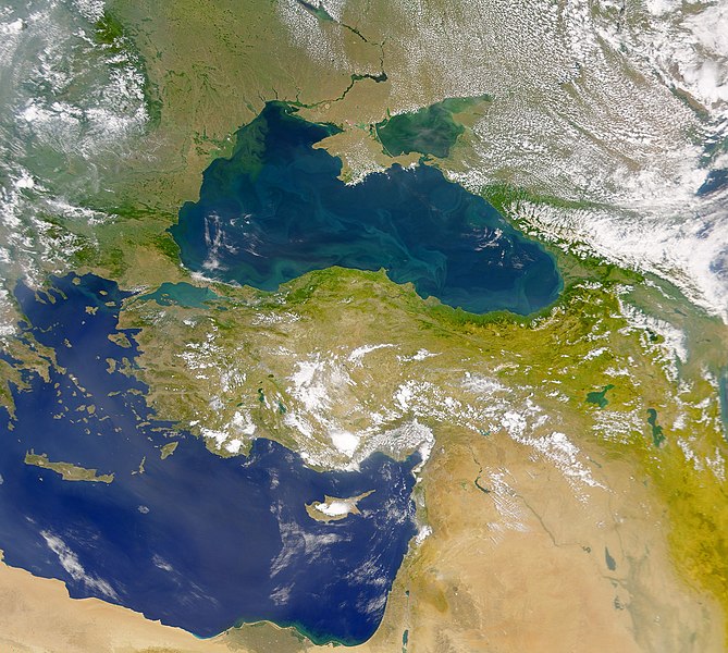
English: This cloud-free Sea-viewing Wide Field-of-view Sensor (SeaWiFS) view of the Black Sea reveals the colourful interplay of currents on the lake’s surface. The green crescent shaped pattern in the north-western corner of the Black Sea is due to the nutrient-rich, sediment-laden discharge of the Danube River stimulating biological activity. The brighter, more turquoise patterns on the lake to the south and east are probably blooms of another type of phytoplankton. |
| Dato | |
| Fonto | NASA Earth Observatory |
| Aŭtoro | The SeaWiFS Project |
Image courtesy of the NASA/Goddard Space Flight Center, and ORBIMAGE.
Permesiloj:
| La ĉi-supra dosiero estas publika havaĵo, ĉar ĝi apartenas al NASA. La kopirajta regularo de NASA asertas, ke "ĉiuj dokumentoj de NASA estas publika havaĵo, se ne estas donata kontraŭa deklaro". | ||
 |
Atentu:
|
Dosierhistorio
Alklaku iun daton kaj horon por vidi kiel la dosiero tiam aspektis.
| Dato/Horo | Bildeto | Grandecoj | Uzanto | Komento | |
|---|---|---|---|---|---|
| nun | 11:20, 20 apr. 2010 | | 2 080 × 1 865 (1,07 MB) | Originalwana | {{Information |Description={{en|1=This cloud-free Sea-viewing Wide Field-of-view Sensor (SeaWiFS) view of the Black Sea reveals the colourful interplay of currents on the lake’s surface. The green crescent shaped pattern in the north-western cor |
Dosiera uzado
La jena paĝo ligas al ĉi tiu dosiero:
Suma uzado de la dosiero
La jenaj aliaj vikioj utiligas ĉi tiun dosieron:
- Uzado en ady.wikipedia.org
- Uzado en crh.wikipedia.org
- Uzado en en.wikipedia.org
- Uzado en fr.wikipedia.org
- Uzado en gu.wikipedia.org
- Uzado en hak.wikipedia.org
- Uzado en hr.wikipedia.org
- Uzado en hu.wikipedia.org
- Uzado en ilo.wikipedia.org
- Uzado en ja.wikipedia.org
- Uzado en kn.wikipedia.org
- Uzado en lg.wikipedia.org
- Uzado en pl.wikipedia.org
- Uzado en rm.wikipedia.org
- Uzado en sr.wikipedia.org
- Uzado en ta.wikipedia.org
- Uzado en uk.wikipedia.org
- Uzado en vi.wikipedia.org
- Uzado en wuu.wikipedia.org
- Uzado en zh.wikipedia.org