Dosiero:Un-morocco.png

Bildo en pli alta difino ((3 038 × 2 257 rastrumeroj, grandeco de dosiero: 1,31 MB, MIME-tipo: image/png))
| Jen dosiero de la Wikimedia-Komunejo. La priskribo en ties priskriba paĝo estas montrata suben.
|
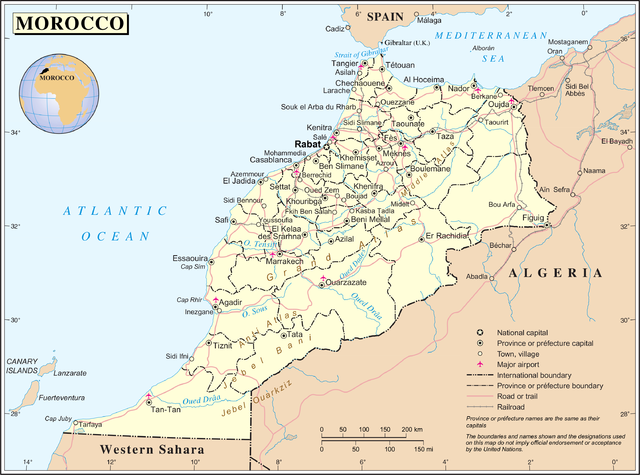
| Priskribo | Map of Morocco | |||
| Dato | ||||
| Fonto | The Cartographic Section of the United Nations (CSUN) | |||
| Aŭtoro | Cartographer of the United Nations | |||
| Permeso (Reuzo de la dosiero) |
|

Please note that the boundaries of internal administrative division of Morocco in this map (provinces, prefectures, regions etc.) are no longer correct.
Dosierhistorio
Alklaku iun daton kaj horon por vidi kiel la dosiero tiam aspektis.
| Dato/Horo | Bildeto | Grandecoj | Uzanto | Komento | |
|---|---|---|---|---|---|
| nun | 15:24, 23 okt. 2007 | | 3 038 × 2 257 (1,31 MB) | Jeroen | {{UN maps}} Category:Maps of Morocco |
Dosiera uzado
Suma uzado de la dosiero
La jenaj aliaj vikioj utiligas ĉi tiun dosieron:
- Uzado en ar.wikipedia.org
- Uzado en bh.wikipedia.org
- Uzado en de.wikipedia.org
- Uzado en en.wikipedia.org
- Uzado en fr.wikipedia.org
- Uzado en id.wikipedia.org
- Uzado en lb.wikipedia.org
- Uzado en lt.wikipedia.org
- Uzado en nl.wikipedia.org
- Uzado en pl.wiktionary.org
- Uzado en sco.wikipedia.org
- Uzado en tr.wikipedia.org
- Uzado en uk.wikipedia.org