The Catlins
46° 30′ S 169° 30′ O / 46.500 °S, 169.500 °O (mapo)

| The Catlins | ||
|---|---|---|
 | ||
| teritorio [+] | ||
| Lando | Nov-Zelando | |
| - koordinatoj | 46° 30′ 0″ S, 169° 30′ 0″ O (mapo)-46.5169.5Koordinatoj: 46° 30′ 0″ S, 169° 30′ 0″ O (mapo) | |
 |
||
| The Catlins | ||

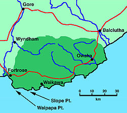
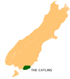
The Catlins aŭ Katlinio (foje aluditaj kiel The Catlins Coast aŭ Katlina Marbordo) enhavas areon en la sudorienta angulo de la Suda Insulo de Novzelando.[1] La areo kuŝas inter Balkluto kaj Invercargill, ĉevalrajde sur la limo inter la regionoj Otago kaj Sudlando. Ĝi enhavas la plej sudan pinton de la Suda Insulo nome Slope Point.
Notoj
redakti- ↑ The Catlins. Arkivigite je 2010-05-22 per la retarkivo Wayback Machine Land Information New Zealand. Konsultita la 12an de novembro 2010.
Referencoj
redakti- Bishop, D. G. kaj Turnbull, I. M. (kompilistoj) (1996). Geology of the Dunedin Area. Lower Hutt, NZ: Institute of Geological & Nuclear Sciences. ISBN 0-478-09521-X.
- Buckingham, R. kaj Hall-Jones, J. (1985). The Catlins. Invercargill: Department of Conservation. ISBN 0-477-05758-6.
- Catlins Walks kaj Tracks Information (1993). Owaka: Department of Conservation/Te Papa Atawhai.
- Dann, C. kaj Peat, N. (1989). Dunedin, North and South Otago. Wellington: GP Books. ISBN 0-477-01438-0.
- Hogan, C. M. (2009) Yellow-eyed Penguin: Megadyptes antipodes Arkivigite je 2011-10-05 per la retarkivo Wayback Machine. In N. Stromberg (ed.), GlobalTwitcher.com. Retrieved 30 September 2010.
- Kirkpatrick, R. (1999). Bateman Contemporary Atlas of New Zealand: The Shapes of Our Nation. Auckland: David Bateman Ltd. ISBN 1-86953-408-5.
- Peat, N. (1998). The Catlins and the Southern Scenic Route. Dunedin: University of Otago Press. ISBN 1-877133-42-6.
- Tyrrell, A. R. (1989). Catlins Pioneering. Dunedin: Otago Heritage Books. ISBN 0-473-07935-6.
Eksteraj ligiloj
redakti- Catlins Promotions Association website
- Southern Scenic Route guide Arkivigite je 2010-03-31 per la retarkivo Wayback Machine and map Arkivigite je 2010-05-20 per la retarkivo Wayback Machine (Department of Conservation)
- Guide to the Hocken Collection's holdings on the Catlins[rompita ligilo]
- Vrako de Surat


