Uzanto:Haruo/Nacia Parko Glacier Bay
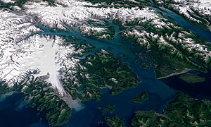
Ŝablono:Infobox Protected area Glacier Bay National Park and Preserve constitutes two official park units jointly managed by the National Park Service in the Alaska panhandle west of Juneau. President Calvin Coolidge first proclaimed the area around Glacier Bay a national monument under the Antiquities Act on February 25, 1925.[1]. Subsequent to an expansion of the monument by President Jimmy Carter in 1978, the Alaska National Interest Lands Conservation Act (ANILCA) enlarged the national monument by 523,000 acres (2116.5 km²) on December 2, 1980 and in the process created Glacier Bay National Park.[2] Similarly ANILCA set aside 57,000 additional acres (230.7 km²) of public land for Glacier Bay National Preserve located to the immediate northwest of the park in order to protect a portion of the Alsek River and related fish and wildlife habitats.
Glacier Bay became part of a binational UNESCO World Heritage Site in 1979, was inscribed as a Biosphere Reserve in 1986 and in 1994 undertook an obligation to work with Hoonah and Tlingit Native American organizations in the management of the protected area.[3] In total the park and preserve cover 5,130 square miles (13,287 km²). Most of Glacier Bay is designated wilderness area which covers 4,164 square miles (10,784 km²).[4]

History
redaktiJoseph Whidbey, master of the Discovery during George Vancouver's 1791-95 expedition, found Icy Strait, at the south end of Glacier Bay, choked with ice in 1794. Glacier Bay itself was almost entirely covered by one large tidewater glacier.[5] In 1879 naturalist John Muir found that the ice had retreated almost all the way up the bay, a distance of around 48 miles (77 km).[6] By 1916 the Grand Pacific Glacier was at the head of Tarr Inlet about 65 miles (105 km) from Glacier Bay's mouth. This is the fastest glacier retreat ever documented.[7] That said, not all of park's glaciers are in retreat.[7] Scientists working in the park and preserve hope to learn how glacial activity relates to climate change.
Environment
redaktiGlacier Bay National Park preserves nearly 600,000 acres (2428.1 km²) of federally protected marine ecosystems in Alaska (including submerged lands) against which other less protected marine ecosystems can be compared.[3] Within both the park and preserve, there are two Tlingit ancestral homelands that are of cultural and spiritual significance to living communities today.[3] The Alsek River serves as a route of discovery and migration from the coastal mountain range in the park to the Pacific Ocean in the preserve.[3] Within the preserve, in contrast to the park, the Alsek River provides a setting for subsistence uses, commercial fishing activities, and hunting as provided for in the Alaska National Interest Lands Conservation Act (ANILCA) while simultaneously protecting the glacial ecosytem.[3]
No roads lead to the park and it is most easily reached by air travel. During some summers there are ferries to the small community of Gustavus or directly to the marina at Bartlett Cove.[7] Despite the lack of roads, there are over 400,000 visitors each year most of whom arrive via cruise ship. The number of ships that may arrive each day is limited by regulation.[7] Other travelers come on white-water rafting trips, putting in on the Tatshenshini River at Dalton Post in the Yukon Territory and taking out at the Dry Bay Ranger Station in the Glacier Bay National Preserve.[8] Trips generally take six days and pass through Kluane National Park and Reserve in the Yukon and Tatshenshini-Alsek Provincial Park in British Columbia.[8]
Glaciers descending from high snow capped mountains into the bay create spectacular displays of ice and iceberg formation. In the last century, the most dramatic was probably the Muir Glacier. The calving face was nearly 2 miles (3.2 km) wide and about 265 feet (81 m) high. Glacier Bay National Park and Preserve includes nine tidewater glaciers. Four of these glaciers actively calve icebergs into the bay. In the 1990s, the Muir Glacier receded to the point that it was no longer a tidewater glacier. Most visitors today travel to the Margerie and Lamplugh Glaciers.
Wildlife in the area includes both grizzly and black bears, moose, sitka black-tailed deer, mountain goats, dall sheep, wolves, Canada lynx, sea otters, harbor seals, Steller sea lions, Pacific white-sided dolphins, orcas, minke whales, humpback whale, bald eagless, gulls, waterfowl, and salmon.
World Heritage Site
redaktiThe Kluane-Wrangell-St. Elias-Glacier Bay-Tatshenshini-Alsek transborder park system comprising Kluane, Wrangell-St Elias, Glacier Bay and Tatshenshini-Alsek parks, was declared a UNESCO World Heritage Site in 1979 for the spectacular glacier and icefield landscapes as well as for the importance of grizzly bears, caribou and Dall sheep habitat.
References
redakti- ↑ . The Story of the Antiquities Act. National Park Service Archaeology Program. Alirita 3 march 2012 . Chapter 8
- ↑ Alaska National Interest Lands Conservation Act. Fish and Wildlife Service. Alirita 3 March 2012 . Title 2, section 202(1).
- ↑ 3,0 3,1 3,2 3,3 3,4 Glacier Bay National Park & Preserve (April 2010) Glacier Bay National Park & Preserve Foundation Statement. Alirita 3 March 2012 .
- ↑ National Park Service Office of Public Affairs and Harpers Ferry Center (July 2009) The National Parks: Index 2009–2011. Alirita 3 March 2012 .
- ↑ Vancouver, George, and John Vancouver. (1801; vols. I-VI) A Voyage of Discovery to the North Pacific Ocean, and Round the World. London: J. Stockdale.
- ↑ Muir, John Travels in Alaska. Sierra Club. Alirita 3 March 2012 .
- ↑ 7,0 7,1 7,2 7,3 National Park Service (2010) Glacier Bay Park & Preserve Factsheet. Alirita 3 March 2012 .
- ↑ 8,0 8,1 National Park Service Glacier Bay Rafting.
External links
redakti- Official website: Glacier Bay National Park and Preserve
- World Heritage Site
- Glacier Bay National Monument in Glimpses of Our National Monuments (1930)
- Haruo/Nacia Parko Glacier Bay en Vikivojaĝo (Turisma gvidilo)
Ŝablono:National parks of the United States Ŝablono:World Heritage Sites in the United States of America Ŝablono:Protected Areas of Alaska